IMAGES TAKEN NEAR TO
Bogmoor Place, GLASGOW, G51 4SN
Introduction
This page details the photographs taken nearby to Bogmoor Place, G51 4SN by members of the Geograph project.
The Geograph project started in 2005 with the aim of publishing, organising and preserving representative images for every square kilometre of Great Britain, Ireland and the Isle of Man.

There are currently over 7.5m images from over14,400 individuals and you can help contribute to the project by visiting https://www.geograph.org.uk
Image Map
Images are licensed for reuse under creativecommons.org/licenses/by-sa/2.0
Notes
- Clicking on the map will re-center to the selected point.
- The higher the marker number, the further away the image location is from the centre of the postcode.
Image Listing (24 Images Found)
Images are licensed for reuse under creativecommons.org/licenses/by-sa/2.0
Image
Details
Distance
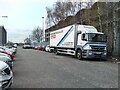
1
Marble Direct
Located at the corner of Bogmoor Place and Renfrew Road.
According to their website, they are 'Scotland’s leading natural stone specialists, providing the very best quality granite, quartz and marble to homes and businesses up and down the country'. They produce fireplaces, marble and granite worktops, tiles, flooring and other products.
Image: © Richard Sutcliffe
Taken: 26 Apr 2021
0.03 miles
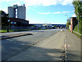
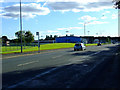
2
Renfrew Road
Looking towards the sharp right turn at the King George V Dock junction.
Image: © Thomas Nugent
Taken: 25 Sep 2010
0.06 miles
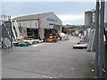
3
King George V Dock
The road to the dock from Renfrew Road.
Image: © Thomas Nugent
Taken: 25 Sep 2010
0.08 miles
4
King George V Dock
The road leads from Renfrew Road to the dock which is commonly known as "the KGV".
Image: © Thomas Nugent
Taken: 25 Sep 2010
0.09 miles
6
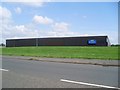
Prince's soft drinks factory, Shieldhall
Makers of Jucee and Ocean Spray, among others.
Image: © Stephen Sweeney
Taken: 27 Jul 2008
0.13 miles
7
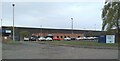
Princes Glasgow
On Bogmoor Road. Princes is one of Europe’s largest food and drink groups.
Image: © Richard Sutcliffe
Taken: 26 Apr 2021
0.16 miles
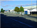
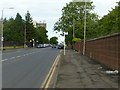
8
Renfrew Road
Looking towards Shieldhall Road. The blue building on the left is a Civic Amenity Site.
Image: © Thomas Nugent
Taken: 25 Sep 2010
0.19 miles
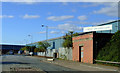
9
Renfrew Road, Shieldhall
Looking west near the Hospital entrance.
Image: © Alan Murray-Rust
Taken: 25 Jun 2019
0.19 miles