IMAGES TAKEN NEAR TO
Mallaig Road, GLASGOW, G51 4PE
Introduction
This page details the photographs taken nearby to Mallaig Road, G51 4PE by members of the Geograph project.
The Geograph project started in 2005 with the aim of publishing, organising and preserving representative images for every square kilometre of Great Britain, Ireland and the Isle of Man.

There are currently over 7.5m images from over14,400 individuals and you can help contribute to the project by visiting https://www.geograph.org.uk
Image Map
Images are licensed for reuse under creativecommons.org/licenses/by-sa/2.0
Notes
- Clicking on the map will re-center to the selected point.
- The higher the marker number, the further away the image location is from the centre of the postcode.
Image Listing (19 Images Found)
Images are licensed for reuse under creativecommons.org/licenses/by-sa/2.0
Image
Details
Distance
1
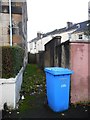
Alley off Holmfauldhead Drive
Leading to the rear of the properties on the left.
Image: © Richard Sutcliffe
Taken: 13 Nov 2018
0.12 miles
3
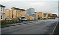
Properties on Holmfauldhead Drive
Modern designs contrast with the traditional tenements behind.
Image: © Richard Sutcliffe
Taken: 13 Nov 2018
0.16 miles
4
St Kenneth Drive, Linthouse
Looking towards the Southern General Hospital clock tower.
Image: © Lynn M Reid
Taken: 22 Mar 2008
0.17 miles
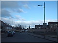
5
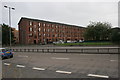
Tenement, Burghead Drive
Looking across the A739 just south of the Clyde Tunnel towards the tenements on Burghead Drive.
Image: © Richard Sutcliffe
Taken: 28 Aug 2015
0.19 miles
6
Queen Elizabeth National Spinal Injuries Unit
Part of the Queen Elizabeth University Hospital campus. The Unit is responsible for the acute and lifelong care of all adult patients in Scotland with traumatic and non-progressive spinal cord injury.
Image: © Richard Sutcliffe
Taken: 26 Apr 2021
0.20 miles
7
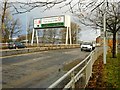
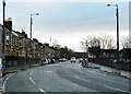
The A739 just south of the Clyde Tunnel
Image: © Richard Sutcliffe
Taken: 13 Nov 2018
0.21 miles
8
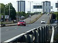
Clyde Tunnel southern approach, Shieldhall Road flyover ? 1
The signs on the approach show that the flyover is restricted to vehicles of 7.5 tonnes maximum weight. This view http://www.geograph.org.uk/photo/6195007 shows exactly why!
Image: © Alan Murray-Rust
Taken: 25 Jun 2019
0.21 miles
9
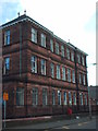
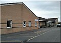
Elder Park Primary School
School on St Kenneth Drive, Linthouse was opened on the 18thn August 1899 and still serves as a school.
Image: © Lynn M Reid
Taken: 22 Mar 2008
0.21 miles
10
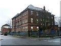
Former school building and doctor's surgery
Located on St Kenneth Drive in Linthouse.
Image: © Stephen Sweeney
Taken: 18 Dec 2008
0.21 miles