IMAGES TAKEN NEAR TO
Ardnish Street, GLASGOW, G51 4ND
Introduction
This page details the photographs taken nearby to Ardnish Street, G51 4ND by members of the Geograph project.
The Geograph project started in 2005 with the aim of publishing, organising and preserving representative images for every square kilometre of Great Britain, Ireland and the Isle of Man.

There are currently over 7.5m images from over14,400 individuals and you can help contribute to the project by visiting https://www.geograph.org.uk
Image Map
Images are licensed for reuse under creativecommons.org/licenses/by-sa/2.0
Notes
- Clicking on the map will re-center to the selected point.
- The higher the marker number, the further away the image location is from the centre of the postcode.
Image Listing (14 Images Found)
Images are licensed for reuse under creativecommons.org/licenses/by-sa/2.0
Image
Details
Distance
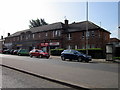
1
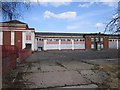
Drumoyne Primary School
The closed Drumoyne Primary School. The school has been merged with neighbours and is now part of Pirie Park School.
Image: © Richard Webb
Taken: 9 Apr 2013
0.10 miles
2
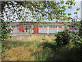
The former Drumoyne Primary School
On Shieldhall Road.
Image: © Ian S
Taken: 26 Aug 2013
0.11 miles
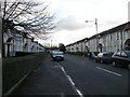
3
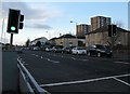
Shieldhall Road
From the traffic lights beside Balbeg Street.
Image: © Richard Sutcliffe
Taken: 22 Feb 2016
0.13 miles
4
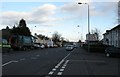
Shieldhall Road
From the junction with Balbeg Street.
Image: © Richard Sutcliffe
Taken: 22 Feb 2016
0.14 miles
6
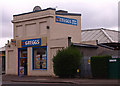
Bakers, Drymoyne
On the busy Shieldhall Road a popular stopping point at lunch time in Glasgow.
Image: © wfmillar
Taken: 15 Apr 2011
0.16 miles
8
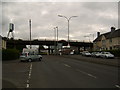
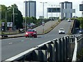
A739 Flyover
At Shieldhall Road. Leads to the Clyde Tunnel.
Image: © Stephen Sweeney
Taken: 16 Aug 2007
0.23 miles
9
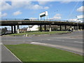
Clyde Tunnel southern approach, Shieldhall Road flyover ? 1
The signs on the approach show that the flyover is restricted to vehicles of 7.5 tonnes maximum weight. This view http://www.geograph.org.uk/photo/6195007 shows exactly why!
Image: © Alan Murray-Rust
Taken: 25 Jun 2019
0.23 miles
10
A739 Flyover
Viewed from Shieldhall Road (A8), the A739 is about 1 mile south of the Clyde Tunnel at this point.
Image: © G Laird
Taken: 2 Apr 2010
0.23 miles