IMAGES TAKEN NEAR TO
Langcroft Place, GLASGOW, G51 4HZ
Introduction
This page details the photographs taken nearby to Langcroft Place, G51 4HZ by members of the Geograph project.
The Geograph project started in 2005 with the aim of publishing, organising and preserving representative images for every square kilometre of Great Britain, Ireland and the Isle of Man.

There are currently over 7.5m images from over14,400 individuals and you can help contribute to the project by visiting https://www.geograph.org.uk
Image Map
Images are licensed for reuse under creativecommons.org/licenses/by-sa/2.0
Notes
- Clicking on the map will re-center to the selected point.
- The higher the marker number, the further away the image location is from the centre of the postcode.
Image Listing (53 Images Found)
Images are licensed for reuse under creativecommons.org/licenses/by-sa/2.0
Image
Details
Distance
1
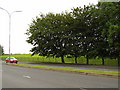
Cardonald Park from Shieldhall Road
The park lies between Shieldhall Road and the M8. A bit of peace between all that hustle!
Image: © Stephen Sweeney
Taken: 16 Aug 2007
0.08 miles
2
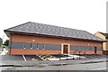
Masonic Lodge, Govan
Lodge The Royal Stuart No.1414, Govan, Glasgow.
Image: © Jim Campbell
Taken: 12 Aug 2007
0.11 miles
3
Luma Tower
Info extracted from the internet: "The former Luma Lamp Factory on Shieldhall Road, is a famous Glasgow landmark and, indeed, a gateway building in the City, and is included in the Scottish Minister's List of Buildings of Special Architectural or Historic Interest as category 'B' listed. Its distinctive and principal feature is a tall conning tower situated at the south west corner rising to a height of 84 ft. The building was completed in 1938."
Image: © Darrin Antrobus
Taken: 24 May 2007
0.14 miles
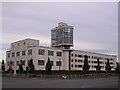
4
Luma Apartment Building
The former Luma Lamp Factory on Shieldhall Road.
Image: © wfmillar
Taken: 15 Apr 2011
0.14 miles
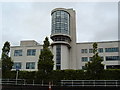
5
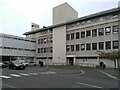
Neurology Block
Part of the Institute of Neurology at Queen Elizabeth University Hospital. The overbridge over Langlands Drive joins it to the other Institute of Neurology building.
Image: © Richard Sutcliffe
Taken: 26 Apr 2021
0.15 miles
6
The Luma Tower
Magnificent piece of 30's Art-Deco, the Luma Tower was completed in 1938. Highly visible from the M8 motorway. Once a lightbulb factory, before selling caravans as 'Caravan Land'. Now converted into 43 flats. More info here: http://ihbc.org.uk/context_archive/65/luma/tower.html
Image: © Chris Upson
Taken: 29 Sep 2005
0.15 miles
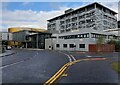
7
Former Luma lamp factory
Built in 1936 as an electric light factory. It later became Caravanland and then McNair Engineering. It was converted to residential accommodation and offices in 1995-96. Category B listed https://portal.historicenvironment.scot/designation/LB33308.
Image: © Richard Sutcliffe
Taken: 11 Sep 2023
0.15 miles
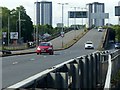
8

A739 crossing Shieldhall Road
This is a flyover across the roundabout
Image: © John Firth
Taken: 17 May 2013
0.16 miles
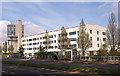
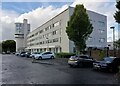
9
Institute of Neurological Sciences
Part of Queen Elizabeth University Hospital.
Image: © Richard Sutcliffe
Taken: 11 Sep 2023
0.16 miles
10
Clyde Tunnel southern approach, Shieldhall Road flyover ? 1
The signs on the approach show that the flyover is restricted to vehicles of 7.5 tonnes maximum weight. This view http://www.geograph.org.uk/photo/6195007 shows exactly why!
Image: © Alan Murray-Rust
Taken: 25 Jun 2019
0.16 miles