IMAGES TAKEN NEAR TO
Fifty Pitches Place, GLASGOW, G51 4GA
Introduction
This page details the photographs taken nearby to Fifty Pitches Place, G51 4GA by members of the Geograph project.
The Geograph project started in 2005 with the aim of publishing, organising and preserving representative images for every square kilometre of Great Britain, Ireland and the Isle of Man.

There are currently over 7.5m images from over14,400 individuals and you can help contribute to the project by visiting https://www.geograph.org.uk
Image Map
Images are licensed for reuse under creativecommons.org/licenses/by-sa/2.0
Notes
- Clicking on the map will re-center to the selected point.
- The higher the marker number, the further away the image location is from the centre of the postcode.
Image Listing (16 Images Found)
Images are licensed for reuse under creativecommons.org/licenses/by-sa/2.0
Image
Details
Distance
1

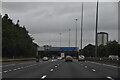
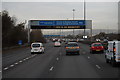
M8, Glasgow
Where the M8 motorway passes close to the centre of the city, it forms part of the (still incomplete) Glasgow Inner Ring Road and is both the busiest and widest motorway in Scotland and the most elaborate urban motorway in Britain (http://www.sabre-roads.org.uk/wiki/index.php?title=M8 SABRE)
Note the typical “Glasgow-type” sign gantry with the following distinctive elements:
• Near and offside support legs (basically 2 rectangular hollow sections with base plates to allow connections to the foundations)
• A Main Frame (made up of rectangular hollow sections) - Over clad on the front and rear.
• A Sub Frame (made up of smaller hollow sections and welded to main frame).
• A Sign Face - acrylic sheets hung from the front of the sub frame over its full height.
• Internal Electrics - sign lighting provided through the use of several dozen fluorescent battens.
Gantries of this type were first erected as part of the construction of the Kingston Bridge and its approach roads in 1970 and they are now a familiar sight on the network around Glasgow.
More information on “Glasgow Style Gantries” at http://www.glasgows-motorways.co.uk/glasgow-gantries/4578281645 (Glasgow’s Motorways)
Image: © David Dixon
Taken: 24 Mar 2014
0.15 miles
3

Glasgow (Shieldhall) Royal Observer Corps Post
The Royal Observer Corps Underground Monitoring Post at Shieldhall, Glasgow.
Image: © Unknown
Taken: 19 Feb 2005
0.21 miles
4

Hillington Industrial Estate
On Johnstone Avenue with Hepburn Road on the left. Wind Turbines plumb lamppost not.
Image: © wfmillar
Taken: 4 Nov 2011
0.21 miles

7

The Luma Tower
Magnificent piece of 30's Art-Deco, the Luma Tower was completed in 1938. Highly visible from the M8 motorway. Once a lightbulb factory, before selling caravans as 'Caravan Land'. Now converted into 43 flats. More info here: http://ihbc.org.uk/context_archive/65/luma/tower.html
Image: © Chris Upson
Taken: 29 Sep 2005
0.22 miles
8

Cardonald Park from Shieldhall Road
The park lies between Shieldhall Road and the M8. A bit of peace between all that hustle!
Image: © Stephen Sweeney
Taken: 16 Aug 2007
0.23 miles
9

Former Luma lamp factory
Built in 1936 as an electric light factory. It later became Caravanland and then McNair Engineering. It was converted to residential accommodation and offices in 1995-96. Category B listed https://portal.historicenvironment.scot/designation/LB33308.
Image: © Richard Sutcliffe
Taken: 11 Sep 2023
0.24 miles
10

Luma Tower
Part of the former Luma Lamp factory, built in 1936. It later became Caravanland and then McNair Engineering. It was converted to residential accommodation and offices in 1995-96. Category B listed https://portal.historicenvironment.scot/designation/LB33308.
Image: © Richard Sutcliffe
Taken: 11 Sep 2023
0.24 miles