IMAGES TAKEN NEAR TO
Kincraig Street, GLASGOW, G51 4ES
Introduction
This page details the photographs taken nearby to Kincraig Street, G51 4ES by members of the Geograph project.
The Geograph project started in 2005 with the aim of publishing, organising and preserving representative images for every square kilometre of Great Britain, Ireland and the Isle of Man.

There are currently over 7.5m images from over14,400 individuals and you can help contribute to the project by visiting https://www.geograph.org.uk
Image Map
Images are licensed for reuse under creativecommons.org/licenses/by-sa/2.0
Notes
- Clicking on the map will re-center to the selected point.
- The higher the marker number, the further away the image location is from the centre of the postcode.
Image Listing (51 Images Found)
Images are licensed for reuse under creativecommons.org/licenses/by-sa/2.0
Image
Details
Distance
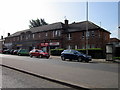
1
Meiklewood Road
The building on the left is part of Mctear's Auctioneers.
Image: © Richard Sutcliffe
Taken: 22 Feb 2016
0.07 miles
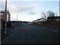
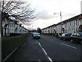
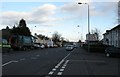
2
Shieldhall Road
From the traffic lights beside Balbeg Street.
Image: © Richard Sutcliffe
Taken: 22 Feb 2016
0.08 miles
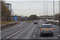
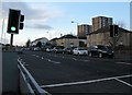
6
M8 at Cardonald
Looking east from the bridge carrying Berryknowes Road over the motorway.
Image: © Alan Murray-Rust
Taken: 25 Jun 2019
0.14 miles
7
Shieldhall Road
From the junction with Balbeg Street.
Image: © Richard Sutcliffe
Taken: 22 Feb 2016
0.14 miles
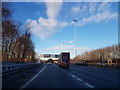
9
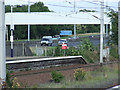
Cardonald railway station and the M8 Motorway
The east end of the east bound platform.
Image: © Thomas Nugent
Taken: 21 Aug 2010
0.15 miles
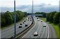
10
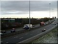
The M8 passing Cardonald
With the early morning traffic heading into Glasgow.
Image: © Stephen Sweeney
Taken: 4 Mar 2009
0.15 miles