IMAGES TAKEN NEAR TO
Linthouse Road, GLASGOW, G51 4BZ
Introduction
This page details the photographs taken nearby to Linthouse Road, G51 4BZ by members of the Geograph project.
The Geograph project started in 2005 with the aim of publishing, organising and preserving representative images for every square kilometre of Great Britain, Ireland and the Isle of Man.

There are currently over 7.5m images from over14,400 individuals and you can help contribute to the project by visiting https://www.geograph.org.uk
Image Map
Images are licensed for reuse under creativecommons.org/licenses/by-sa/2.0
Notes
- Clicking on the map will re-center to the selected point.
- The higher the marker number, the further away the image location is from the centre of the postcode.
Image Listing (47 Images Found)
Images are licensed for reuse under creativecommons.org/licenses/by-sa/2.0
Image
Details
Distance
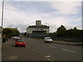
1
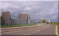
Linthouse Road, Govan
On the left Thales' Govan factory in Glasgow which specialises in high performance electro-optic night vision equipment and systems.
Image: © wfmillar
Taken: 15 Apr 2011
0.09 miles
3
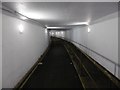
Clyde Tunnel (northbound)
A path under the road deck for bikes and walkers. This is a new altitude record on a bike for me, c -10m.
Image: © Richard Webb
Taken: 4 Jan 2016
0.11 miles
4
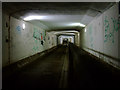
The Clyde Tunnel
Climbing south from the dip under the Clyde on the southbound pedestrian and cyclists' tunnel. A bit more graffiti than I recall since my last ride through here around thirty years ago. The tunnel is not as dark as it appears in this photo.
See the road tunnels here Image & Image
Image: © Thomas Nugent
Taken: 25 Sep 2010
0.11 miles
5
Southside entrance to Clyde Tunnel
From Holmfauld Road.
Image: © Stephen Sweeney
Taken: 16 Aug 2007
0.12 miles
6
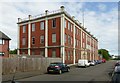
Linthouse Buildings, Holmfauld Road
Now named Alexander Stephens House, housing The Riverbank Centre.
Former design office building for the Alexander Stephens shipyard, built 1914, using the Considere reinforced concrete system. Listed Category B http://portal.historicenvironment.scot/designation/LB33309
Image: © Alan Murray-Rust
Taken: 25 Jun 2019
0.14 miles
7
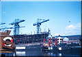
Whiteinch Car Ferry
The vehicular ferry ran alongside a small foot passenger ferry. The image was taken from the TMS Queen Mary II which was on an excursion down the river, The shipyard on the left is part of the Barclay Curle shipyard.
Image: © H. Mykura
Taken: 5 Jul 1957
0.15 miles
8
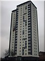
Whiteinch Highrise
Highrise flats at Smith street. A fire occurred in one of the flats recently.
Image: © Lynn M Reid
Taken: 26 Mar 2008
0.15 miles
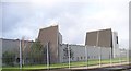
9
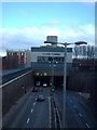
Clyde Tunnel South
South entrance to the Clyde Tunnel. Alexander Stephen's Building is on the left. Former site of the Stephens Shipyard.
Image: © Lynn M Reid
Taken: 22 Mar 2008
0.16 miles
10
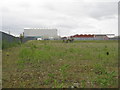
Wasteland at Linthouse
The Clyde Tunnel passes under the immediate foreground, and beyond are shipyard buildings.
Image: © M J Richardson
Taken: 4 May 2014
0.16 miles