IMAGES TAKEN NEAR TO
Harmony Row, GLASGOW, G51 3BB

Introduction

This page details the photographs taken nearby to Harmony Row, G51 3BB by members of the Geograph project.

The Geograph project started in 2005 with the aim of publishing, organising and preserving representative images for every square kilometre of Great Britain, Ireland and the Isle of Man.

There are currently over 7.5m images from over14,400 individuals and you can help contribute to the project by visiting https://www.geograph.org.uk

Image Map


Images are licensed for reuse under creativecommons.org/licenses/by-sa/2.0
Notes
  • Clicking on the map will re-center to the selected point.
  • The higher the marker number, the further away the image location is from the centre of the postcode.

Image Listing (337 Images Found)

Images are licensed for reuse under creativecommons.org/licenses/by-sa/2.0
  • ...
Image
Details
Distance
1
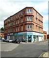
Harmony Row Pharmacy
On the corner of Harmony Row and Langlands Road.
Image: © Richard Sutcliffe Taken: 20 Jul 2019
0.01 miles
2
Six Harmony Row
Part of Govan Workspace Ltd, Six Harmony Row provides 40 workspaces ideal for office or studio activities in three adjoining buildings.
Image: © Richard Sutcliffe Taken: 20 Jul 2019
0.02 miles
3
Langlands Road shops
Viewed from Golspie Street.
Image: © Stephen Sweeney Taken: 18 Dec 2008
0.03 miles
4
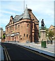
Sir William Pearce statue at Govan Cross
In memory of the 19th Century shipbuilder and former Govan MP.
Image: © Stephen Sweeney Taken: 18 Dec 2008
0.03 miles
5
Brechins
Seen from Burleigh Street. The building dates from 1894. The public house is on the ground floor, with upper floors formerly the Govan Conservative Association Halls. It is Category B listed https://portal.historicenvironment.scot/designation/LB33344.
Image: © Richard Sutcliffe Taken: 28 Jun 2023
0.03 miles
6
Brechins
Seen from Burleigh Street. The building dates from 1894. The public house is on the ground floor, with upper floors formerly the Govan Conservative Association Halls. It is Category B listed https://portal.historicenvironment.scot/designation/LB33344.
Image: © Richard Sutcliffe Taken: 26 Mar 2024
0.03 miles
7
Along Govan Road
Statue of Sir William Pearce, Brechins Bar and St Anthony's Catholic Church can be seen.
Image: © Lynn M Reid Taken: 22 Mar 2008
0.03 miles
8
Brechins
On Govan Road. The building dates from 1894. The public house is on the ground floor, with upper floors formerly the Govan Conservative Association Halls. It is Category B listed https://portal.historicenvironment.scot/designation/LB33344.
Image: © Richard Sutcliffe Taken: 26 Mar 2024
0.04 miles
9
Cardell Halls, Govan, and Brechin's bar
Category B listed building http://portal.historicenvironment.scot/designation/LB33344 dating from 1894, which was originally built as a Temperance Headquarters. It is now Brechin's Bar. The upper floors above the bar were formerly the Govan Conservative Association Halls. For another recent view see https://www.geograph.org.uk/photo/6205278. The statue beside the building is of Sir William Pearce.
Image: © Richard Sutcliffe Taken: 20 Jul 2019
0.04 miles
10
Doorway, Cardell Halls
An impressive entrance for a taxi office!
Image: © Richard Sutcliffe Taken: 20 Jul 2019
0.04 miles
  • ...