IMAGES TAKEN NEAR TO
Whitefield Road, GLASGOW, G51 2SG
Introduction
This page details the photographs taken nearby to Whitefield Road, G51 2SG by members of the Geograph project.
The Geograph project started in 2005 with the aim of publishing, organising and preserving representative images for every square kilometre of Great Britain, Ireland and the Isle of Man.

There are currently over 7.5m images from over14,400 individuals and you can help contribute to the project by visiting https://www.geograph.org.uk
Image Map
Images are licensed for reuse under creativecommons.org/licenses/by-sa/2.0
Notes
- Clicking on the map will re-center to the selected point.
- The higher the marker number, the further away the image location is from the centre of the postcode.
Image Listing (121 Images Found)
Images are licensed for reuse under creativecommons.org/licenses/by-sa/2.0
Image
Details
Distance
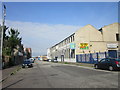
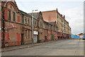
3
Neglected industrial buildings on Fairley Street, Govan
Image: © Steven Brown
Taken: 21 Mar 2010
0.07 miles
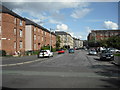
6
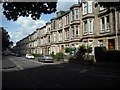
Whitefield Road
Three storey tenements dwarfed by the multi storey flats of Ibroxholm Oval to the west.
Image: © Jim Smillie
Taken: 5 Aug 2009
0.11 miles
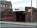
7
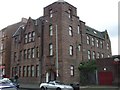
Copland Court
Former brush factory built in 1897. Now a hostel for homeless alcoholics. Next to Ibrox underground station Image
Image: © Thomas Nugent
Taken: 8 Sep 2008
0.11 miles
9
Ibrox Street
Tenements on either side beyond Midlock Street.
Image: © Jim Smillie
Taken: 5 Aug 2009
0.12 miles
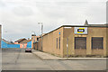
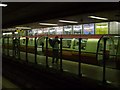
10
Ibrox subway station
On Copland Road.
Image: © Thomas Nugent
Taken: 8 Sep 2008
0.12 miles