IMAGES TAKEN NEAR TO
Copland Place, GLASGOW, G51 2RS
Introduction
This page details the photographs taken nearby to Copland Place, G51 2RS by members of the Geograph project.
The Geograph project started in 2005 with the aim of publishing, organising and preserving representative images for every square kilometre of Great Britain, Ireland and the Isle of Man.

There are currently over 7.5m images from over14,400 individuals and you can help contribute to the project by visiting https://www.geograph.org.uk
Image Map
Images are licensed for reuse under creativecommons.org/licenses/by-sa/2.0
Notes
- Clicking on the map will re-center to the selected point.
- The higher the marker number, the further away the image location is from the centre of the postcode.
Image Listing (130 Images Found)
Images are licensed for reuse under creativecommons.org/licenses/by-sa/2.0
Image
Details
Distance
2
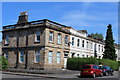
Corner of Brighton Place & Copland Road, Glasgow
Image: © Leslie Barrie
Taken: 9 Jul 2013
0.06 miles
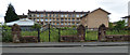
3
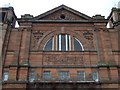
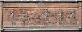
Govan Town Hall
Image: © Thomas Nugent
Taken: 8 Sep 2008
0.07 miles
4
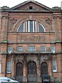
Govan Town Hall
Image: © Thomas Nugent
Taken: 8 Sep 2008
0.07 miles
5
Govan Town Hall
Image: © Thomas Nugent
Taken: 8 Sep 2008
0.07 miles
6
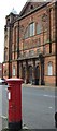
Post box on Summertown Road
King George VI pillar box outside the Royal Mail building on Summertown Road. Govan Town Hall is in the background.
Image: © Thomas Nugent
Taken: 8 Sep 2008
0.07 miles
7
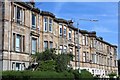
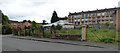
View towards Clynder Street
Tenements of different coloured sandstone.
Image: © Jim Smillie
Taken: 5 Aug 2009
0.07 miles
8
Site of St Saviour's Church
On Merryland Street, with tenements on Summertown Road in the background.
Image: © Thomas Nugent
Taken: 27 Aug 2018
0.07 miles
9
Site of St Saviour's Church
On Merryland Street, with tenements on Summertown Road in the background.
Image: © Thomas Nugent
Taken: 27 Aug 2018
0.07 miles
10
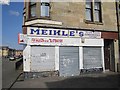
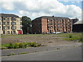
Shop, Brighton Place
A derelict shop for sale, many of the streets in its catchment have been demolished and are now just grass.
Image: © Richard Webb
Taken: 9 Apr 2013
0.08 miles