IMAGES TAKEN NEAR TO
Clifford Street, GLASGOW, G51 1NT
Introduction
This page details the photographs taken nearby to Clifford Street, G51 1NT by members of the Geograph project.
The Geograph project started in 2005 with the aim of publishing, organising and preserving representative images for every square kilometre of Great Britain, Ireland and the Isle of Man.

There are currently over 7.5m images from over14,400 individuals and you can help contribute to the project by visiting https://www.geograph.org.uk
Image Map
Images are licensed for reuse under creativecommons.org/licenses/by-sa/2.0
Notes
- Clicking on the map will re-center to the selected point.
- The higher the marker number, the further away the image location is from the centre of the postcode.
Image Listing (176 Images Found)
Images are licensed for reuse under creativecommons.org/licenses/by-sa/2.0
Image
Details
Distance
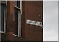
2
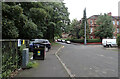
Langshot Street, Cessnock
Residential tenements on Langshot Street, seen from the junction with Clifford Street.
Image: © Barbara Carr
Taken: 30 Apr 2013
0.03 miles
3
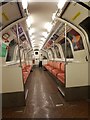
Between Kinning Park and Cessnock
An Outer Line train on the Glasgow Subway.
Image: © DS Pugh
Taken: 6 Apr 2019
0.04 miles
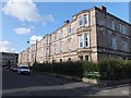
4
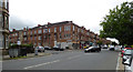
Langshot Street
Typical Glasgow architecture. A north - south running street that links Clifford Street and Paisley Road West. It is a useful road for the pedestrian or cyclist as it links with a footbridge over the M8.
Image: © Richard Webb
Taken: 6 Mar 2010
0.04 miles
5
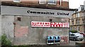
Communities United
Advice centre - taken from a website on community projects in Govan
"Raising Awareness of the Opportunities and
meeting needs and demands of the Ethnic
Minority Community"
Corner of Langshott Street and Paisley Road West.
Image: © Richard Webb
Taken: 24 Sep 2008
0.05 miles
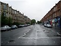
6
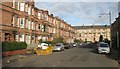
Paisley Road West
Looking west at Langshot Street which is on the left side of the corner
Image: © Thomas Nugent
Taken: 27 Aug 2018
0.05 miles
7
Langshot Street
Corner of Langshot Street and Paisley Road West.
Image: © Richard Webb
Taken: 6 Mar 2010
0.05 miles
8
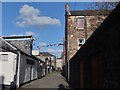
Clifford Lane, Cessnock
Bright bunting marks the entrance to the Psychic Centre in Clifford Lane, which links the mid-points of Percy Street and Langshot Street and runs parallel with Clifford Street.
Image: © Barbara Carr
Taken: 30 Apr 2013
0.05 miles
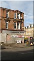
9
Crumbling sandstone
Off Paisley Road West, a sandstone building which was once a shop on the ground floor.
Image: © Richard Webb
Taken: 24 Sep 2008
0.05 miles
10
Paisley Road West
Looking east towards Glasgow.
Image: © Stephen Sweeney
Taken: 3 Aug 2008
0.05 miles