IMAGES TAKEN NEAR TO
St. Luke's Place, GLASGOW, G5 0TS
Introduction
This page details the photographs taken nearby to St. Luke's Place, G5 0TS by members of the Geograph project.
The Geograph project started in 2005 with the aim of publishing, organising and preserving representative images for every square kilometre of Great Britain, Ireland and the Isle of Man.

There are currently over 7.5m images from over14,400 individuals and you can help contribute to the project by visiting https://www.geograph.org.uk
Image Map
Images are licensed for reuse under creativecommons.org/licenses/by-sa/2.0
Notes
- Clicking on the map will re-center to the selected point.
- The higher the marker number, the further away the image location is from the centre of the postcode.
Image Listing (551 Images Found)
Images are licensed for reuse under creativecommons.org/licenses/by-sa/2.0
Image
Details
Distance
1

St Luke's Business Estate
Network Rail owned business park at St Luke's Place. The City Union Railway line runs behind the buildings.
See also Image
Image: © Thomas Nugent
Taken: 8 May 2016
0.01 miles
2

St Luke's Place
The City Union Railway line is on the right.
Image: © Thomas Nugent
Taken: 8 May 2016
0.01 miles
3
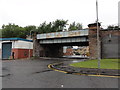
Railway bridge
Railway bridge at St. Luke's Place
Image: © Mat Tuck
Taken: 26 Jun 2016
0.01 miles
4

City Union Railway arches at Cleland Lane
Alongside Cleland Lane, north of Cleland Street, from where the photo was taken. The line is used for freight and empty stock movements, with the occasional special passenger train. The rear of the Citizens Theatre is on the left.
Image: © Thomas Nugent
Taken: 8 May 2016
0.02 miles
5

Cleland Lane railway bridge
The bridge carries the freight and empty stock only City Union Railway line.
Image: © Thomas Nugent
Taken: 8 May 2016
0.02 miles
6

Cleland Lane railway bridge
The underside of the bridge which carries the freight and empty stock only City Union Railway line.
Image: © Thomas Nugent
Taken: 8 May 2016
0.02 miles
7

St Luke's Business Estate
Network Rail owned business park at St Luke's Place. The City Union Railway line runs behind the buildings.
See also Image
Image: © Thomas Nugent
Taken: 8 May 2016
0.02 miles
8

Citizens Theatre
The rear of the Category B Listed http://portal.historicenvironment.scot/designation/LB33512 theatre, on Cleland Lane. The City Union Railway line is on the left.
Image: © Thomas Nugent
Taken: 8 May 2016
0.03 miles
9

Citizens Theatre
The rear of the Category B Listed http://portal.historicenvironment.scot/designation/LB33512 theatre, on Cleland Lane. The City Union Railway line is on the left.
Image: © Thomas Nugent
Taken: 8 May 2016
0.03 miles
10

City Union Railway arches
Alongside Cleland Lane, north of Cleland Street, from where the photo was taken. The line is used for freight and empty stock movements, with the occasional special passenger train.
Image: © Thomas Nugent
Taken: 8 May 2016
0.03 miles