IMAGES TAKEN NEAR TO
Thistle Terrace, GLASGOW, G5 0SJ
Introduction
This page details the photographs taken nearby to Thistle Terrace, G5 0SJ by members of the Geograph project.
The Geograph project started in 2005 with the aim of publishing, organising and preserving representative images for every square kilometre of Great Britain, Ireland and the Isle of Man.

There are currently over 7.5m images from over14,400 individuals and you can help contribute to the project by visiting https://www.geograph.org.uk
Image Map
Images are licensed for reuse under creativecommons.org/licenses/by-sa/2.0
Notes
- Clicking on the map will re-center to the selected point.
- The higher the marker number, the further away the image location is from the centre of the postcode.
Image Listing (244 Images Found)
Images are licensed for reuse under creativecommons.org/licenses/by-sa/2.0
Image
Details
Distance
1
View of Glasgow
View into the city centre from Cathcart Road where it crosses the M74. The big glass wall is the St Enoch's shopping centre.
Image: © Richard Webb
Taken: 29 Jun 2011
0.02 miles
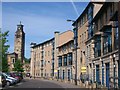
2

Cumberland Street
Malta Street is to the right of the building.
Image: © Thomas Nugent
Taken: 8 May 2016
0.02 miles
3

The Brazen Head beer garden
At the rear of the pub, the front of which is on the other side of the railway arch.
Image: © Thomas Nugent
Taken: 8 May 2016
0.03 miles
4
Alexander Crescent, Gorbals
This is one part of the successful regeneration of what was once one of Glasgow's most notorious areas
Image: © C L T Smith
Taken: 1 Jun 2008
0.04 miles
5

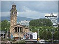
Caledonia Road UP Church
Derelict, but preserved United Presbyterian church by Alexander 'Greek' Thomson. More details here http://www.greekthomson.com/Caledonia%20Road%20Church.htm See also Image
Image: © Thomas Nugent
Taken: 20 Aug 2007
0.04 miles
6

Cumberland Street
Viewed across the site of the Sandieford Road towerblocks which were demolished in July 2013.
Image: © Thomas Nugent
Taken: 8 May 2016
0.04 miles
7
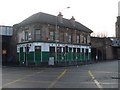
Brazen Head, Gorbals
Pub in Glasgow's South Side with very strong ties to the Irish community. Named after a prophetic head which in legend had the answer to any question.
Image: © Stephen Sweeney
Taken: 17 Dec 2008
0.05 miles
8
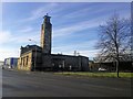
Caledonia Road United Presbyterian Church
Designed by architect Alexander "Greek" Thomson in 1856-7, the church was the victim of an arson attack in 1965.
Image: © Euan Nelson
Taken: 6 Feb 2018
0.05 miles
9

Cumberland Street railway bridges
The nearer bridge carries the disused trackbed of the Glasgow, Barrhead and Neilston Direct Railway. The further bridge carries the City Union line which is used for freight and empty stock movements, plus the occasional special passenger train.
Image: © Thomas Nugent
Taken: 8 May 2016
0.05 miles
10

Cumberland Street railway bridges
The nearer bridge carries the disused trackbed of the Glasgow, Barrhead and Neilston Direct Railway. The further bridge carries the City Union line which is used for freight and empty stock movements, plus the occasional special passenger train.
Image: © Thomas Nugent
Taken: 8 May 2016
0.05 miles