IMAGES TAKEN NEAR TO
Errol Gardens, GLASGOW, G5 0RR
Introduction
This page details the photographs taken nearby to Errol Gardens, G5 0RR by members of the Geograph project.
The Geograph project started in 2005 with the aim of publishing, organising and preserving representative images for every square kilometre of Great Britain, Ireland and the Isle of Man.

There are currently over 7.5m images from over14,400 individuals and you can help contribute to the project by visiting https://www.geograph.org.uk
Image Map
Images are licensed for reuse under creativecommons.org/licenses/by-sa/2.0
Notes
- Clicking on the map will re-center to the selected point.
- The higher the marker number, the further away the image location is from the centre of the postcode.
Image Listing (259 Images Found)
Images are licensed for reuse under creativecommons.org/licenses/by-sa/2.0
Image
Details
Distance
1
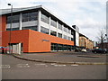
Gorbals Library
The local Glasgow Housing Association office is housed in the upper floors. 9th April 2010 4.35pm.
Image: © Gordon Dowie
Taken: 9 Apr 2010
0.04 miles
2

Site of Sandiefiled Road towerblocks
Two large towerblocks stood here until July 2013.
Image: © Thomas Nugent
Taken: 8 May 2016
0.07 miles
3
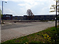
Site of Sandiefiled Road towerblocks
Two large towerblocks stood here until July 2013.
Image: © Thomas Nugent
Taken: 8 May 2016
0.09 miles
4

Cumberland Street
Viewed across the site of the Sandieford Road towerblocks which were demolished in July 2013.
Image: © Thomas Nugent
Taken: 8 May 2016
0.09 miles
5
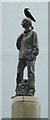
Girl With A Rucksack statue
Kenny Hunter’s 'Girl With A Rucksack' stands on top of a high plinth at the junction of Cumberland Street and Jane Place. It is one of several sculptures in the Gorbals area, and was unveiled in June 2004.
It makes a good perch for the local crows.
Image: © Richard Sutcliffe
Taken: 30 Aug 2017
0.11 miles
6

Gorbals Parish Church
At the corner of Laurieston Road (on left) and Hospital Street.
Image: © Thomas Nugent
Taken: 8 May 2016
0.11 miles
7

Gorbals Parish Church
At the corner of Laurieston Road (on left) and Hospital Street.
Image: © Thomas Nugent
Taken: 8 May 2016
0.12 miles
8
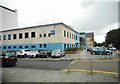
Police Station
At 383 Cumberland Street.
Image: © Richard Sutcliffe
Taken: 30 Aug 2017
0.12 miles
9

Laurieston Road
At Cleland Street, which is on the left.
Image: © Thomas Nugent
Taken: 8 May 2016
0.12 miles
10

Cumberland Street
Malta Street is to the right of the building.
Image: © Thomas Nugent
Taken: 8 May 2016
0.13 miles