IMAGES TAKEN NEAR TO
Waterside Place, GLASGOW, G5 0QD
Introduction
This page details the photographs taken nearby to Waterside Place, G5 0QD by members of the Geograph project.
The Geograph project started in 2005 with the aim of publishing, organising and preserving representative images for every square kilometre of Great Britain, Ireland and the Isle of Man.

There are currently over 7.5m images from over14,400 individuals and you can help contribute to the project by visiting https://www.geograph.org.uk
Image Map
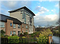
Images are licensed for reuse under creativecommons.org/licenses/by-sa/2.0
Notes
- Clicking on the map will re-center to the selected point.
- The higher the marker number, the further away the image location is from the centre of the postcode.
Image Listing (328 Images Found)
Images are licensed for reuse under creativecommons.org/licenses/by-sa/2.0
Image
Details
Distance
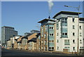
1
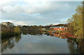
Riverside Path
A new footpath alongside the River Clyde in a very old part of Glasgow which has been redeveloped.
Image: © Mary and Angus Hogg
Taken: 22 Nov 2014
0.01 miles

3
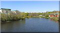
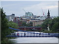
The River Clyde at Glasgow
Looking downstream from King's Bridge towards Glasgow University Boat Club boathouse.
Image: © Thomas Nugent
Taken: 22 Apr 2022
0.03 miles
4
River Clyde
Downstream from King's Bridge
Image: © David Dixon
Taken: 17 Aug 2010
0.03 miles
5
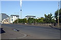
Ballater Street
The A74 through the Gorbals, recently superseded by the nearby M74 motorway.
Image: © Thomas Nugent
Taken: 8 Oct 2012
0.04 miles
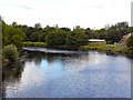
6
The River Clyde
A mid-November view looking downstream from King's Bridge.
Image: © Mary and Angus Hogg
Taken: 22 Nov 2014
0.04 miles
7
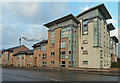
Ballater Street
Modern housing development in a very old part of Glasgow.
Image: © Mary and Angus Hogg
Taken: 22 Nov 2014
0.04 miles
8
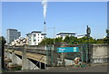
Kings Bridge
At 70 feet wide, it is possible to cross this stretch of road without realising that the River Clyde runs underneath.
Image: © Thomas Nugent
Taken: 8 Oct 2012
0.05 miles
9
Kings Bridge
The upstream side of the bridge which was built in 1933 and carries the A74 over the River Clyde.
Image: © Thomas Nugent
Taken: 8 Oct 2012
0.05 miles
10
Glasgow and the Clyde
Viewed from Glasgow Green. The tower on the right is the Briggait Centre Image
Image: © Thomas Nugent
Taken: 16 Aug 2008
0.05 miles