IMAGES TAKEN NEAR TO
Waddell Court, GLASGOW, G5 0PU
Introduction
This page details the photographs taken nearby to Waddell Court, G5 0PU by members of the Geograph project.
The Geograph project started in 2005 with the aim of publishing, organising and preserving representative images for every square kilometre of Great Britain, Ireland and the Isle of Man.

There are currently over 7.5m images from over14,400 individuals and you can help contribute to the project by visiting https://www.geograph.org.uk
Image Map
Images are licensed for reuse under creativecommons.org/licenses/by-sa/2.0
Notes
- Clicking on the map will re-center to the selected point.
- The higher the marker number, the further away the image location is from the centre of the postcode.
Image Listing (457 Images Found)
Images are licensed for reuse under creativecommons.org/licenses/by-sa/2.0
Image
Details
Distance
1
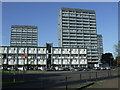
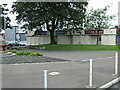
Adelphi Street towerblocks
Overlooking the Clyde and Glasgow Green.
Image: © Thomas Nugent
Taken: 8 Oct 2012
0.02 miles
2
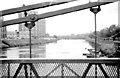
River Clyde and Gorbals from St Andrew's Suspension Bridge, c1963
Image: © Donald MacDonald
Taken: Unknown
0.02 miles
3
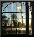
Gorbals brewery chimney
Viewed from within the People's Palace museum on Glasgow Green.
Image: © Thomas Nugent
Taken: 7 Dec 2008
0.02 miles
4
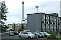
Adelphi Street
The Strathclyde Distillery is in very close proximity to the flats.
Image: © Thomas Nugent
Taken: 11 Aug 2014
0.03 miles
5

Evening view of the Gorbals from Glasgow Green
Image: © Christopher Hilton
Taken: 27 Mar 1993
0.03 miles
6
Riverside Tavern
On Adelphi Street, formerly known as The Tavern Image
Image: © Thomas Nugent
Taken: 11 Aug 2014
0.03 miles
7
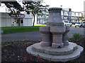
Monument on Adelphi Street
Between the Riverside Tavern and the River Clyde. Origin unknown.
Image: © Thomas Nugent
Taken: 8 Oct 2012
0.03 miles
8

Riverside Tavern
Image: © Thomas Nugent
Taken: 22 Apr 2022
0.03 miles
9

Gorbals brewery chimney
Viewed from Glasgow Green.
Image: © Thomas Nugent
Taken: 7 Dec 2008
0.03 miles
10
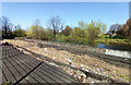
Riverbank subsidence at Adelphi Street
The damage was caused when the nearby Tidal Weir failed in August 2017, resulting in the water level of the River Clyde above the weir dropping to its lowest level for over sixty years. The absence of water pressure in the river resulted in long stretches of the banks collapsing, including this stretch which remains collapsed five years later.
Image: © Thomas Nugent
Taken: 22 Apr 2022
0.03 miles