IMAGES TAKEN NEAR TO
Old Rutherglen Road, GLASGOW, G5 0PE
Introduction
This page details the photographs taken nearby to Old Rutherglen Road, G5 0PE by members of the Geograph project.
The Geograph project started in 2005 with the aim of publishing, organising and preserving representative images for every square kilometre of Great Britain, Ireland and the Isle of Man.

There are currently over 7.5m images from over14,400 individuals and you can help contribute to the project by visiting https://www.geograph.org.uk
Image Map
Images are licensed for reuse under creativecommons.org/licenses/by-sa/2.0
Notes
- Clicking on the map will re-center to the selected point.
- The higher the marker number, the further away the image location is from the centre of the postcode.
Image Listing (115 Images Found)
Images are licensed for reuse under creativecommons.org/licenses/by-sa/2.0
Image
Details
Distance
1
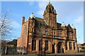
Gorbals Economic & Training Centre, McNeil St, Glasgow
Category B-listed. Built 1904-6 as Hutchesontoun Public Library. Architect J R Rhind.
Image: © Leslie Barrie
Taken: 14 Nov 2013
0.05 miles
2
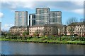
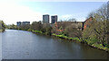
Housing in Hutchesontown
The picture was taken from the Clyde Walkway. On the other side of the river, the nearer houses are on Waterside Street. Of the four visible Image, the two on the right were later demolished. The two on the left are on Silverfir Street.
Image: © Lairich Rig
Taken: 8 Apr 2005
0.08 miles
3
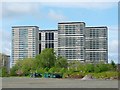
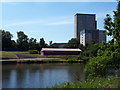
High flats in Hutchesontown
The view is from the other side of the River Clyde. The two tower blocks on the right are now gone.
The picture was taken from a waste area within the Fleshers' Haugh. As indicated by the treetops visible not far ahead, the ground slopes down just beyond the far edge of this area. The slope leads down to the Clyde Walkway, from which another picture shows the same high flats, as well as the nearer buildings whose roofs can be seen in the present picture: Image
Image: © Lairich Rig
Taken: 6 May 2005
0.09 miles
4
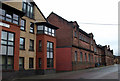
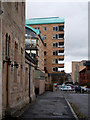
Old Rutherglen Road
Looking east from Saint Valentine Terrace.
Image: © Thomas Nugent
Taken: 10 Nov 2012
0.10 miles
5
The River Clyde in Glasgow
Looking towards Oatlands from King's Bridge.
Image: © Thomas Nugent
Taken: 22 Apr 2022
0.10 miles
7
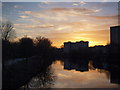
Hutchesontown River Clyde at sunset
The picture looks southwest along the river from the King's Bridge, in the direction of the late December setting sun. The pedestrian and cycle path along the river can be seen at left.
Image: © Alec MacKinnon
Taken: 30 Dec 2014
0.11 miles
8
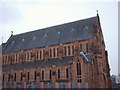
The St. Francis Centre
St Francis Chapel, now a community centre
Image: © Lynn M Reid
Taken: 13 Mar 2008
0.11 miles
9
Sandyfaulds Street
Looking towards Old Rutherglen Road.
Image: © Thomas Nugent
Taken: 10 Nov 2012
0.11 miles
10
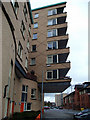
Saint Valentine Terrace
A large overhang on this modern building at the corner of Old Rutherglen Road.
Image: © Thomas Nugent
Taken: 10 Nov 2012
0.11 miles