IMAGES TAKEN NEAR TO
Old Rutherglen Road, GLASGOW, G5 0LT
Introduction
This page details the photographs taken nearby to Old Rutherglen Road, G5 0LT by members of the Geograph project.
The Geograph project started in 2005 with the aim of publishing, organising and preserving representative images for every square kilometre of Great Britain, Ireland and the Isle of Man.

There are currently over 7.5m images from over14,400 individuals and you can help contribute to the project by visiting https://www.geograph.org.uk
Image Map
Images are licensed for reuse under creativecommons.org/licenses/by-sa/2.0
Notes
- Clicking on the map will re-center to the selected point.
- The higher the marker number, the further away the image location is from the centre of the postcode.
Image Listing (182 Images Found)
Images are licensed for reuse under creativecommons.org/licenses/by-sa/2.0
Image
Details
Distance
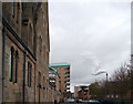
1
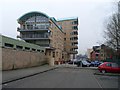
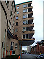
Interesting flat design in Glasgow's Gorbals
It is unusual how the flats overhang the road with no solid base beneath them.
Image: © Stephen Sweeney
Taken: 18 Feb 2009
0.02 miles
2
Old Rutherglen Road
Looking east from Saint Valentine Terrace.
Image: © Thomas Nugent
Taken: 10 Nov 2012
0.03 miles
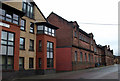
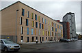
3
Modern Flats, Sandyfauld Street, Glasgow
Image: © Leslie Barrie
Taken: 14 Nov 2013
0.04 miles
4
Old Rutherglen Road
Colourful modern flats at the corner of Waddell Street.
Image: © Thomas Nugent
Taken: 10 Nov 2012
0.04 miles
5
Sandyfaulds Street
Looking towards the distillery at Ballater Street.
Image: © Thomas Nugent
Taken: 10 Nov 2012
0.04 miles
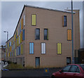
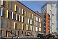
6
Waddell Street
Colourful modern flats with shuttered windows.
Image: © Thomas Nugent
Taken: 10 Nov 2012
0.05 miles
7
Modern Flats, Waddell Street, Glasgow
Image: © Leslie Barrie
Taken: 14 Nov 2013
0.05 miles
8
Sandyfaulds Street
Looking towards Old Rutherglen Road.
Image: © Thomas Nugent
Taken: 10 Nov 2012
0.05 miles
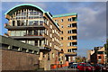
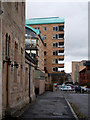
9
Saint Valentine Terrace
A large overhang on this modern building at the corner of Old Rutherglen Road.
Image: © Thomas Nugent
Taken: 10 Nov 2012
0.05 miles
10
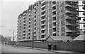
Hutchesontown 'C' tower blocks ? 1964
Under construction in 1964. These blocks were designed by the prominent British Architect Sir Basil Spence (of Coventry Cathedral) as part of the major redevelopment of the Gorbals area which had become notorious for its slum conditions. After early approval by residents, the blocks proved difficult and expensive to maintain, and despite their distinctive design were finally demolished in 1993 after a relatively short life.
Image: © Alan Murray-Rust
Taken: Unknown
0.07 miles