IMAGES TAKEN NEAR TO
Silverfir Street, GLASGOW, G5 0JZ
Introduction
This page details the photographs taken nearby to Silverfir Street, G5 0JZ by members of the Geograph project.
The Geograph project started in 2005 with the aim of publishing, organising and preserving representative images for every square kilometre of Great Britain, Ireland and the Isle of Man.

There are currently over 7.5m images from over14,400 individuals and you can help contribute to the project by visiting https://www.geograph.org.uk
Image Map
Images are licensed for reuse under creativecommons.org/licenses/by-sa/2.0
Notes
- Clicking on the map will re-center to the selected point.
- The higher the marker number, the further away the image location is from the centre of the postcode.
Image Listing (71 Images Found)
Images are licensed for reuse under creativecommons.org/licenses/by-sa/2.0
Image
Details
Distance
1
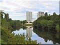
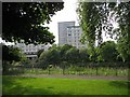
Apartment Blocks
High-rise flats at Hutchesontown, Glasgow. Shot from further up the same bank of the Clyde. The two blocks on the right have since been demolished.
Image: © Roger May
Taken: 9 Aug 2005
0.06 miles
2
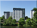
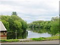
Silver Fir Court
Three housing blocks seen across the Clyde from Glasgow Green.
Image: © Stephen Craven
Taken: 28 Jun 2019
0.06 miles
3
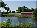
Glasgow Rowing Club
The clubhouse seen across the Clyde from Glasgow Green.
Image: © Stephen Craven
Taken: 28 Jun 2019
0.06 miles
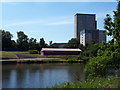
5
Flats, Hutchestontown
Tower blocks off Silverfir Court, seen across the Clyde from Glasgow Green.
Image: © Richard Webb
Taken: 25 Jul 2008
0.06 miles
6
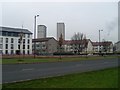
Oatlands
Mix of old and new housing in the area to the south of Glasgow City Centre.
Image: © Stephen Sweeney
Taken: 18 Feb 2009
0.07 miles
7
The Boulevard
Name of this stretch of the new A730 in Oatlands.
Image: © Stephen Sweeney
Taken: 18 Feb 2009
0.07 miles
10
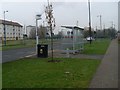
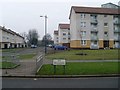
Bus stop, Caledonia Road
In a newly-developed area of Oatlands, south of Glasgow City Centre.
Image: © Stephen Sweeney
Taken: 18 Feb 2009
0.09 miles