IMAGES TAKEN NEAR TO
Provost Way, GLASGOW, G5 0HT
Introduction
This page details the photographs taken nearby to Provost Way, G5 0HT by members of the Geograph project.
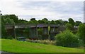
The Geograph project started in 2005 with the aim of publishing, organising and preserving representative images for every square kilometre of Great Britain, Ireland and the Isle of Man.

There are currently over 7.5m images from over14,400 individuals and you can help contribute to the project by visiting https://www.geograph.org.uk
Image Map
Images are licensed for reuse under creativecommons.org/licenses/by-sa/2.0
Notes
- Clicking on the map will re-center to the selected point.
- The higher the marker number, the further away the image location is from the centre of the postcode.
Image Listing (79 Images Found)
Images are licensed for reuse under creativecommons.org/licenses/by-sa/2.0
Image
Details
Distance
1
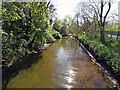
The Polmadie Burn
Looking upstream from the footbridge just before the burn enters the Clyde.
Image: © Thomas Nugent
Taken: 22 Apr 2022
0.04 miles
2
Footbridge over the Polmadie Burn
The burn enters the Clyde (seen on the left) at this point.
Image: © Thomas Nugent
Taken: 22 Apr 2022
0.05 miles
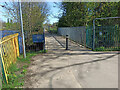
3
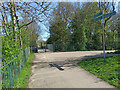
Footpaths at Polmadie Footbridge
The path on the right leads to the bridge. Straight ahead leads to a small footbridge over the Polmadie Burn and the riverside path to Richmond Park and beyond.
Image: © Thomas Nugent
Taken: 22 Apr 2022
0.05 miles
4
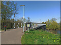
Polmadie Footbridge
Looking north to the reconstructed bridge towards Glasgow Green. The deck of the previous bridge was demolished in 2015 and the piers were eventually used to support the new bridge which opened in 2017.
Image: © Thomas Nugent
Taken: 22 Apr 2022
0.06 miles
5
Polmadie Footbridge
Spans the River Clyde between Glasgow Green and Oatlands.
Image: © william craig
Taken: Unknown
0.06 miles
6

Polmadie Footbridge
Looking downstream to the reconstructed bridge and Glasgow Green. The deck of the previous bridge was demolished in 2015 and the piers were eventually used to support the new bridge which opened in 2017.
Image: © Thomas Nugent
Taken: 22 Apr 2022
0.06 miles
7

Haughview Terrace, Oatlands, Glasgow
Six-storey housing blocks under construction beside the River Clyde. These form part of the Oatlands Regeneration project, led by Glasgow City Council (lead developer - Gladedale). Nearly 1,300 houses are being built and Richmond Park is being upgraded as part of the scheme.
Image: © RON SMITH
Taken: 9 Aug 2007
0.06 miles
8
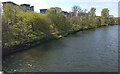
The River Clyde in Glasgow
Fairly new apartment blocks on the south bank at Haughview Terrace in Oatlands. Viewed from Polmadie Footbridge.
Image: © Thomas Nugent
Taken: 22 Apr 2022
0.07 miles
9
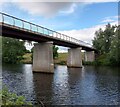
Polmadie Bridge
Footbridge over Clyde to Glasgow Green
Image: © Jim Smillie
Taken: 14 Jul 2022
0.08 miles
10

The new Polmadie bridge - detail
This footbridge across the Clyde near the east end of Glasgow Green, opened in September 2018, replaced a less elegant 1950s structure Image
Image: © Stephen Craven
Taken: 28 Jun 2019
0.09 miles