IMAGES TAKEN NEAR TO
Rosebery Terrace, GLASGOW, G5 0AU
Introduction
This page details the photographs taken nearby to Rosebery Terrace, G5 0AU by members of the Geograph project.
The Geograph project started in 2005 with the aim of publishing, organising and preserving representative images for every square kilometre of Great Britain, Ireland and the Isle of Man.

There are currently over 7.5m images from over14,400 individuals and you can help contribute to the project by visiting https://www.geograph.org.uk
Image Map
Images are licensed for reuse under creativecommons.org/licenses/by-sa/2.0
Notes
- Clicking on the map will re-center to the selected point.
- The higher the marker number, the further away the image location is from the centre of the postcode.
Image Listing (50 Images Found)
Images are licensed for reuse under creativecommons.org/licenses/by-sa/2.0
Image
Details
Distance
1
Doomed
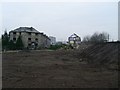
This area of Polmadie, Glasgow, is in the path of the extension to the M74 motorway. It will soon be levelled for the roadworks to commence.
Image: © Roger May
Taken: 9 Aug 2005
0.07 miles
2
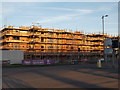
Oatlands housing development
New houses are being built in this area beside the M74.
Image: © Alec MacKinnon
Taken: 21 Jan 2017
0.08 miles
3
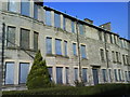
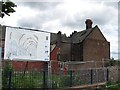
Old Oatlands
8 Granton Street,Due to be demolished as part of a regeneration programme.
Image: © Lynn M Reid
Taken: 19 Feb 2008
0.09 miles
4
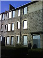
No Entry!
8 Granton Street,Oatlands G5. Family once lived in top flat. Soon to be demolished.
Image: © Lynn M Reid
Taken: 19 Feb 2008
0.09 miles
5
Demolition of Granton Street, Oatlands
From Old Rutherglen Road.
Image: © Stephen Sweeney
Taken: 18 Feb 2009
0.09 miles
6
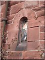
Broken Stained Glass.
Little window at St Margaret's church Polmadie Road.
Image: © Lynn M Reid
Taken: 24 Mar 2008
0.10 miles
7
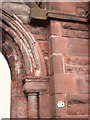
110 Polmadie Road
Stonework at St. Margaret's church
Image: © Lynn M Reid
Taken: 24 Mar 2008
0.11 miles
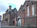
8
St Margaret's Oatlands
Former church, now derelict. It is hoped to convert the building to a community centre.
Image: © Richard Webb
Taken: 29 Jun 2011
0.11 miles
9
St. Margaret's Church, Polmadie Road.
It was in this church that my parents married. Me and my brother were also christened here. plans are proposed to convert it to a community centre for the regenerated Oatlands area.
Image: © Lynn M Reid
Taken: 24 Mar 2008
0.12 miles
10
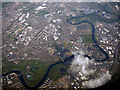
East Glasgow from the air
Glasgow Green, Richmond Park and Shawfield Stadium are in the foreground. Bridgeton Cross is to the left of centre. Celtic Park and the Emirates Arena are at the top, centre. The River Clyde meanders through the scene, as does the M74 motorway.
From left to right, the bridges over the Clyde are St Andrews suspension bridge, King's Bridge, Polmadie Bridge, Rutherglen Bridge, the Smart Bridge (in cloud), Dalmarnock railway bridge, Dalmarnock road bridge and the distant M74 Auchenshuggle Bridge.
Image: © Thomas Nugent
Taken: 1 May 2017
0.12 miles