IMAGES TAKEN NEAR TO
Farnell Street, GLASGOW, G4 9SE
Introduction
This page details the photographs taken nearby to Farnell Street, G4 9SE by members of the Geograph project.
The Geograph project started in 2005 with the aim of publishing, organising and preserving representative images for every square kilometre of Great Britain, Ireland and the Isle of Man.

There are currently over 7.5m images from over14,400 individuals and you can help contribute to the project by visiting https://www.geograph.org.uk
Image Map
Images are licensed for reuse under creativecommons.org/licenses/by-sa/2.0
Notes
- Clicking on the map will re-center to the selected point.
- The higher the marker number, the further away the image location is from the centre of the postcode.
Image Listing (228 Images Found)
Images are licensed for reuse under creativecommons.org/licenses/by-sa/2.0
Image
Details
Distance
1
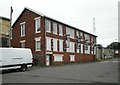
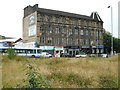
GAMTA, Farnell Street
GAMTA http://www.gamta.org.uk/ was founded in 1994 as the home and pioneer of world-class musical theatre training in Scotland.
Image: © Richard Sutcliffe
Taken: 24 Jul 2020
0.01 miles
2
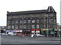
Possil Road
A grand building at the junction with Garscube Road.
Image: © Thomas Nugent
Taken: 13 Feb 2009
0.01 miles
3
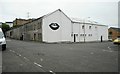
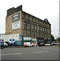
Glue Factory
According to their website http://thegluefactory.org/about/, 'The Glue Factory is an independent arts venue and workspace in north Glasgow. The organisation was founded in 2011 as a non-profit community interest company by a committee of people working across art, design, architecture, music and event production.'
'Construction on the original building started in 1891, designed by John Keppie (with the assistance of a junior Charles Rennie Macintosh) it has had many uses - from a mineral water factory, manufacturing of Argyle Cycles, and finally Scottish Adhesives Company who left the building vacant for 12 years before it started to be used for cultural activity in 2010. '
Image: © Richard Sutcliffe
Taken: 24 Jul 2020
0.02 miles
4
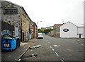
Farnell Street
Originally called Fleming Street.
Image: © Richard Sutcliffe
Taken: 24 Jul 2020
0.02 miles
5
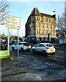
Tower Buildings
Numbers 2-14 Possil Road dates from 1875 and is Category B listed http://portal.historicenvironment.scot/designation/LB33776. The Tower Bar is located at number 8.
Image: © Richard Sutcliffe
Taken: 24 Jul 2020
0.03 miles
6
Tower Buildings
Numbers 2-14 Possil Road dates from 1875 and is Category B listed http://portal.historicenvironment.scot/designation/LB33776. The Tower Bar is located at number 8.
Image: © Richard Sutcliffe
Taken: 24 Jul 2020
0.03 miles
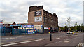
7
Tower Buildings
On the corner of Possil Road and Farnell Street, the block dates from 1875 and is Category B listed http://portal.historicenvironment.scot/designation/LB33776.
Image: © Richard Sutcliffe
Taken: 9 Dec 2022
0.03 miles
9
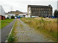
Former street
A former street beside Garscube Cross, now really just a wide path. In the 1890s it was called Society Row, but the name was later changed to Carnbroe Street. Today the cobbles remain, but the original buildings are gone. The area to the right is now just an unkept grassy triangle.
Image: © Richard Sutcliffe
Taken: 24 Jul 2020
0.05 miles
10
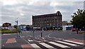
Junction of St George's Road and Garscube Road (A81), Glasgow
Possil Road can also be seen running in front of the big building.
Image: © habiloid
Taken: 30 Jul 2021
0.06 miles