IMAGES TAKEN NEAR TO
Hopeman Path, GLASGOW, G46 8SF
Introduction
This page details the photographs taken nearby to Hopeman Path, G46 8SF by members of the Geograph project.
The Geograph project started in 2005 with the aim of publishing, organising and preserving representative images for every square kilometre of Great Britain, Ireland and the Isle of Man.

There are currently over 7.5m images from over14,400 individuals and you can help contribute to the project by visiting https://www.geograph.org.uk
Image Map
Images are licensed for reuse under creativecommons.org/licenses/by-sa/2.0
Notes
- Clicking on the map will re-center to the selected point.
- The higher the marker number, the further away the image location is from the centre of the postcode.
Image Listing (48 Images Found)
Images are licensed for reuse under creativecommons.org/licenses/by-sa/2.0
Image
Details
Distance
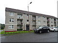
1
Flats, Hopeman Path
Viewed from Kennisholm Place.
Image: © Richard Sutcliffe
Taken: 13 Jan 2017
0.02 miles
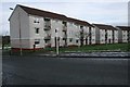
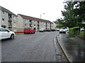
2
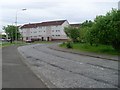
Kennishead Place
Residential area in the south of Glasgow.
Image: © Stephen Sweeney
Taken: 25 May 2009
0.02 miles
3
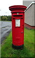
Postbox on Kennishead Place
Postbox No. G46 1464.
Image: © JThomas
Taken: 14 Sep 2021
0.03 miles
4

Pillarbox, Kennishead Place
Postbox number G46 1464D.
Image: © Richard Sutcliffe
Taken: 13 Jan 2017
0.03 miles
6
Flats on Hopeman Avenue, Thornliebank, Glasgow
Image: © JThomas
Taken: 14 Sep 2021
0.04 miles
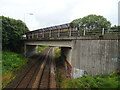
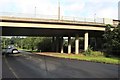
7

Footbridge over railway
By Kennishead Road and the M77.
Image: © Stephen Sweeney
Taken: 25 May 2009
0.07 miles