IMAGES TAKEN NEAR TO
Drumpark Street, GLASGOW, G46 8LR
Introduction
This page details the photographs taken nearby to Drumpark Street, G46 8LR by members of the Geograph project.
The Geograph project started in 2005 with the aim of publishing, organising and preserving representative images for every square kilometre of Great Britain, Ireland and the Isle of Man.

There are currently over 7.5m images from over14,400 individuals and you can help contribute to the project by visiting https://www.geograph.org.uk
Image Map
Images are licensed for reuse under creativecommons.org/licenses/by-sa/2.0
Notes
- Clicking on the map will re-center to the selected point.
- The higher the marker number, the further away the image location is from the centre of the postcode.
Image Listing (28 Images Found)
Images are licensed for reuse under creativecommons.org/licenses/by-sa/2.0
Image
Details
Distance
3

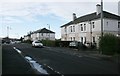
Thornliebank Primary School
Seen from Bangorshill Street.
Image: © Richard Sutcliffe
Taken: 13 Jan 2017
0.12 miles
4
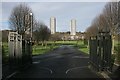
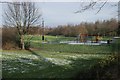
Entrance to King George V Park
The gates into the park from Boydestone Road, with the Kennishead flats in the distance.
Image: © Richard Sutcliffe
Taken: 13 Jan 2017
0.12 miles
5
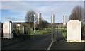
Entrance to King George V Park
The gates into the park from Boydestone Road, with the Kennishead flats in the distance.
Image: © Richard Sutcliffe
Taken: 13 Jan 2017
0.12 miles
7
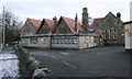
Thornliebank Primary School
Seen from Bangorshill Street. The school is a Category B listed building.
Image: © Richard Sutcliffe
Taken: 13 Jan 2017
0.14 miles
9
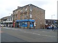
Old tenement on Thornliebank Main Street
The date stone puts the building at 107 years old - it was built in 1902.
Image: © Stephen Sweeney
Taken: 13 Jun 2009
0.14 miles
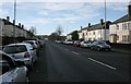
10
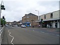
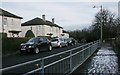
Thornliebank Main Street
Looking in the direction to the roundabout at Rouken Glen Road.
Image: © Stephen Sweeney
Taken: 13 Jun 2009
0.15 miles