IMAGES TAKEN NEAR TO
Kilmuir Close, GLASGOW, G46 8AZ
Introduction
This page details the photographs taken nearby to Kilmuir Close, G46 8AZ by members of the Geograph project.
The Geograph project started in 2005 with the aim of publishing, organising and preserving representative images for every square kilometre of Great Britain, Ireland and the Isle of Man.

There are currently over 7.5m images from over14,400 individuals and you can help contribute to the project by visiting https://www.geograph.org.uk
Image Map
Images are licensed for reuse under creativecommons.org/licenses/by-sa/2.0
Notes
- Clicking on the map will re-center to the selected point.
- The higher the marker number, the further away the image location is from the centre of the postcode.
Image Listing (9 Images Found)
Images are licensed for reuse under creativecommons.org/licenses/by-sa/2.0
Image
Details
Distance
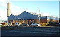
1
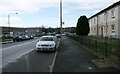
Carnwadric Road
East Renfrewshire Council's Thornliebank depot is on the left.
Image: © Richard Sutcliffe
Taken: 13 Jan 2017
0.20 miles
2

Evanton Drive, Thornliebank Industrial Estate
Image: © Richard Sutcliffe
Taken: 28 Nov 2017
0.20 miles
3

Inverarity Morton, Evanton Drive, Thornliebank Industrial Estate
Scotland’s leading privately-owned drinks distributor.
Image: © Richard Sutcliffe
Taken: 28 Nov 2017
0.20 miles
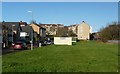
6
Thornliebank Industrial Estate
Thornlie Bank Industrial estate on a winter's day
Image: © Bob Shires
Taken: 6 Feb 2007
0.23 miles
7
Caledonia House, Thornliebank Industrial Estate
On Spiersbridge Avenue.
Image: © Richard Sutcliffe
Taken: 28 Nov 2017
0.24 miles
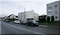
8
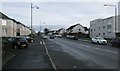
Carnwadric Road
Ardconnie Street is on the left.
Image: © Richard Sutcliffe
Taken: 13 Jan 2017
0.24 miles
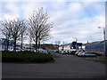
9
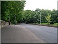
Country road feel to main city road
Spiersbridge Road in Glasgow.
Image: © Stephen Sweeney
Taken: 13 Jun 2009
0.25 miles