IMAGES TAKEN NEAR TO
Burnfield Cottages, GLASGOW, G46 7UD
Introduction
This page details the photographs taken nearby to Burnfield Cottages, G46 7UD by members of the Geograph project.
The Geograph project started in 2005 with the aim of publishing, organising and preserving representative images for every square kilometre of Great Britain, Ireland and the Isle of Man.

There are currently over 7.5m images from over14,400 individuals and you can help contribute to the project by visiting https://www.geograph.org.uk
Image Map
Images are licensed for reuse under creativecommons.org/licenses/by-sa/2.0
Notes
- Clicking on the map will re-center to the selected point.
- The higher the marker number, the further away the image location is from the centre of the postcode.
Image Listing (42 Images Found)
Images are licensed for reuse under creativecommons.org/licenses/by-sa/2.0
Image
Details
Distance
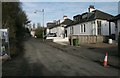
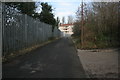
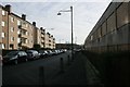
2
Burnfield Cottages
Burnfield Cottages is the name of the road.
Image: © Richard Sutcliffe
Taken: 5 Jan 2017
0.03 miles
3
Old wall
This wall has sloping paving slabs in front of it, and clearly related to a previous structure. The area on the other side of the wall is now empty, but Google shows the outline of a previous building there. There are a few bits of graffiti on the harled surface of the wall.
Image: © Richard Sutcliffe
Taken: 5 Jan 2017
0.04 miles
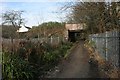
4
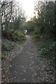
Footpath to Robslee Drive
This was once a continuation of Robslee Drive, and some maps give the indication that it still is. It is now just a footpath leading from Burnfield Road to the bridge under the railway line, where it joins the current Robslee Drive. The path is lined on both sides by trees.
Image: © Richard Sutcliffe
Taken: 5 Jan 2017
0.04 miles
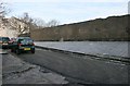
5
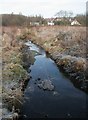
The Auldhouse Burn
Looking towards the railway.
Image: © Richard Sutcliffe
Taken: 5 Jan 2017
0.05 miles
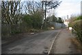
6
Railway Bridge, at end of Robslee Drive
Robslee Drive effectively ends here, although it continues as a footpath under the railway and on to Burnfield Road.
Image: © Richard Sutcliffe
Taken: 5 Jan 2017
0.05 miles
7
Railway Bridge, at end of Robslee Drive
Seen from the open ground to the south of the railway.
Photographed on a frosty January day.
Image: © Richard Sutcliffe
Taken: 5 Jan 2017
0.05 miles
8

Railway bridge over the Auldhouse Burn
The railway crosses the Auldhouse Burn about 400 metres southeast of Thornliebank Station. The yellow barriers are temporary fences to stop people getting onto the railway line.
Photographed on a frosty January day.
Image: © Richard Sutcliffe
Taken: 5 Jan 2017
0.05 miles
9
Burnfield Cottages
Burnfield Cottages is the name of the road. The flats in the distance are on Burnfield Road.
Image: © Richard Sutcliffe
Taken: 5 Jan 2017
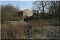
0.06 miles
10
Burnfield Road, Thornliebank
Blocks of flats on the left overlook the former, and now empty, Toffolo Jackson (stone specialists) premises on the right. The site is likely to be redeveloped as housing in the near future.
Image: © Richard Sutcliffe
Taken: 5 Jan 2017
0.07 miles