IMAGES TAKEN NEAR TO
Atholl Place, Woodlands Park, GLASGOW, G46 7SQ
Introduction
This page details the photographs taken nearby to Atholl Place, Woodlands Park, G46 7SQ by members of the Geograph project.
The Geograph project started in 2005 with the aim of publishing, organising and preserving representative images for every square kilometre of Great Britain, Ireland and the Isle of Man.

There are currently over 7.5m images from over14,400 individuals and you can help contribute to the project by visiting https://www.geograph.org.uk
Image Map
Images are licensed for reuse under creativecommons.org/licenses/by-sa/2.0
Notes
- Clicking on the map will re-center to the selected point.
- The higher the marker number, the further away the image location is from the centre of the postcode.
Image Listing (17 Images Found)
Images are licensed for reuse under creativecommons.org/licenses/by-sa/2.0
Image
Details
Distance
1
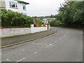
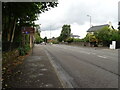
Woodlands Crescent at Thornliebank
Looking southward.
Image: © Peter Wood
Taken: 14 Sep 2016
0.12 miles
2
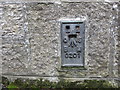
Ordnance Survey Flush Bracket G201
This can be found on the wall of the former Woodlands parish Church - now private apartments.
For more detail see : http://www.bench-marks.org.uk/bm16861
Image: © Peter Wood
Taken: 14 Sep 2016
0.15 miles
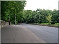
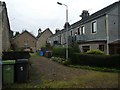
3
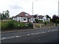
Housing on Rouken Glen Road
In Thornliebank.
Image: © Stephen Sweeney
Taken: 13 Jun 2009
0.15 miles
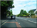
7
Country road feel to main city road
Spiersbridge Road in Glasgow.
Image: © Stephen Sweeney
Taken: 13 Jun 2009
0.18 miles
8
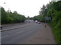
The A727 Nitshill Road
Just east of Spiershall Roundabout.
Image: © Stephen Sweeney
Taken: 13 Jun 2009
0.20 miles
9
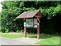
Information sign in Rouken Glen Park
Complete with rain shelter, as a Glasgow park would require.
Image: © Stephen Sweeney
Taken: 13 Jun 2009
0.21 miles
10
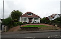
Housing at Rouken Glen Road
Bell tower is on Thornliebank Parish Church.
Image: © Alan Reid
Taken: 5 Nov 2018
0.21 miles