IMAGES TAKEN NEAR TO
Thornliebank Road, GLASGOW, G46 7RJ
Introduction
This page details the photographs taken nearby to Thornliebank Road, G46 7RJ by members of the Geograph project.
The Geograph project started in 2005 with the aim of publishing, organising and preserving representative images for every square kilometre of Great Britain, Ireland and the Isle of Man.

There are currently over 7.5m images from over14,400 individuals and you can help contribute to the project by visiting https://www.geograph.org.uk
Image Map
Images are licensed for reuse under creativecommons.org/licenses/by-sa/2.0
Notes
- Clicking on the map will re-center to the selected point.
- The higher the marker number, the further away the image location is from the centre of the postcode.
Image Listing (52 Images Found)
Images are licensed for reuse under creativecommons.org/licenses/by-sa/2.0
Image
Details
Distance
1
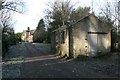
Eastwood New Cemetery
The house in the distance is Eastwood Lodge, situated just inside the gates to the cemetery, opposite the cemetery lodge and waiting room. The rectangular building in the foreground is roofless and derelict.
The cemetery contains Commonwealth War Graves.
Photographed on a frosty January day.
Image: © Richard Sutcliffe
Taken: 5 Jan 2017
0.01 miles
2
Buildings at entrance to Eastwood New Cemetery
The building on the left is the Eastwood New Cemetery Lodge or Waiting Room. It is boarded up, and has apparently been in this state for the last 10 years if not longer. It is on the Buildings at Risk Register for Scotland. See [http://www.buildingsatrisk.org.uk/details/908526].
The building on the right is a private house.
Photographed on a frosty January day.
Image: © Richard Sutcliffe
Taken: 5 Jan 2017
0.01 miles
3
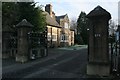
Eastwood Lodge
A private house just inside the gates of Eastwood New Cemetery at 271 Thornliebank Road.
Image: © Richard Sutcliffe
Taken: 5 Jan 2017
0.01 miles
4
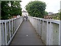
Footbridge by Thornliebank Road
Crosses the railway line near the station.
Image: © Stephen Sweeney
Taken: 13 Jun 2009
0.01 miles
5
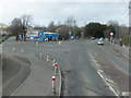
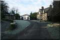
Approaching Thornliebank Station
Heading northeasterly on the B769.
Image: © Barbara Carr
Taken: 22 Apr 2013
0.01 miles
6
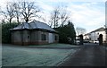
Eastwood New Cemetery Lodge or Waiting Room
The Eastwood New Cemetery Lodge or Waiting Room, beside the entrance to the cemetery on Thornliebank Road. It is boarded up, and has apparently been in this state for the last 10 years if not longer. It is on the Buildings at Risk Register for Scotland. See [http://www.buildingsatrisk.org.uk/details/908526].
Photographed on a frosty January day.
Image: © Richard Sutcliffe
Taken: 5 Jan 2017
0.02 miles
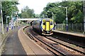
8
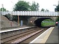
Thornliebank railway station, East Renfrewshire
Opened in 1866 by the Busby Railway which became part of the Caledonian Railway empire, this is on the line from Glasgow Central to East Kilbride. View north west towards Pollokshaws West and Glasgow.
Image: © Nigel Thompson
Taken: 12 Oct 2013
0.02 miles
9
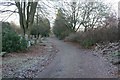
Eastwood New Cemetery
Looking along the road down the northeastern side of the cemetery toward the entrance onto Thornliebank Road.
The cemetery contains Commonwealth War Graves.
Photographed on a frosty January day.
Image: © Richard Sutcliffe
Taken: 5 Jan 2017
0.02 miles
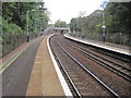
10
Railway tunnel near Thornliebank Station
Where Thornliebank Road crosses the line.
Image: © Stephen Sweeney
Taken: 13 Jun 2009
0.03 miles