IMAGES TAKEN NEAR TO
Norwood Drive, GLASGOW, G46 7LS
Introduction
This page details the photographs taken nearby to Norwood Drive, G46 7LS by members of the Geograph project.
The Geograph project started in 2005 with the aim of publishing, organising and preserving representative images for every square kilometre of Great Britain, Ireland and the Isle of Man.

There are currently over 7.5m images from over14,400 individuals and you can help contribute to the project by visiting https://www.geograph.org.uk
Image Map
Images are licensed for reuse under creativecommons.org/licenses/by-sa/2.0
Notes
- Clicking on the map will re-center to the selected point.
- The higher the marker number, the further away the image location is from the centre of the postcode.
Image Listing (14 Images Found)
Images are licensed for reuse under creativecommons.org/licenses/by-sa/2.0
Image
Details
Distance
2
Road into Eastwood Park
Off Rouken Glen Road.
Image: © Stephen Sweeney
Taken: 13 Jun 2009
0.16 miles
3
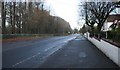
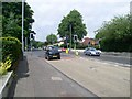
Davieland Road
Looking from the junction with Norwood Drive. Rouken Glen Park is on the left.
Image: © Richard Sutcliffe
Taken: 26 Nov 2018
0.17 miles
5
Thornliebank road junction
Davieland Road at Rouken Glen Road.
Image: © Stephen Sweeney
Taken: 13 Jun 2009
0.19 miles
6
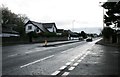
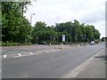
A77, Ayr Road
At the junction with Langtree Avenue.
Image: © Richard Sutcliffe
Taken: 26 Nov 2018
0.20 miles
8
Gate on Davieland Road
Normally locked, the gate is on the edge of Rouken Glen Park. Just on the other side of the gate are a couple of runners in the annual Rouken Glen 10k race.
Image: © Alec MacKinnon
Taken: 7 Jun 2018
0.23 miles
9
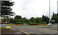
Roundabout on the A727, Giffnock
Junction with the A77.
Image: © JThomas
Taken: 14 Sep 2021
0.23 miles
10
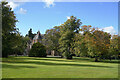
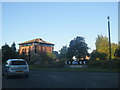
Eastwood Park
Looking across Eastwood Park towards Eastwood House.
Image: © Malcolm Neal
Taken: 24 Sep 2022
0.23 miles