IMAGES TAKEN NEAR TO
Inglestone Avenue, GLASGOW, G46 7ES
Introduction
This page details the photographs taken nearby to Inglestone Avenue, G46 7ES by members of the Geograph project.
The Geograph project started in 2005 with the aim of publishing, organising and preserving representative images for every square kilometre of Great Britain, Ireland and the Isle of Man.

There are currently over 7.5m images from over14,400 individuals and you can help contribute to the project by visiting https://www.geograph.org.uk
Image Map
Images are licensed for reuse under creativecommons.org/licenses/by-sa/2.0
Notes
- Clicking on the map will re-center to the selected point.
- The higher the marker number, the further away the image location is from the centre of the postcode.
Image Listing (7 Images Found)
Images are licensed for reuse under creativecommons.org/licenses/by-sa/2.0
Image
Details
Distance
1
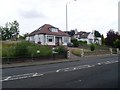
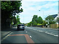
Housing on Rouken Glen Road
In Thornliebank.
Image: © Stephen Sweeney
Taken: 13 Jun 2009
0.17 miles
3
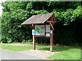
Information sign in Rouken Glen Park
Complete with rain shelter, as a Glasgow park would require.
Image: © Stephen Sweeney
Taken: 13 Jun 2009
0.22 miles
6
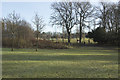
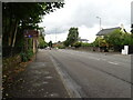
Rouken Glen Park
Looking across the grass from the car park on the way to the child's play centre.
Image: © Malcolm Neal
Taken: 26 Jan 2018
0.23 miles
7
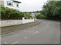
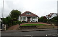
Woodlands Crescent at Thornliebank
Looking southward.
Image: © Peter Wood
Taken: 14 Sep 2016
0.24 miles