IMAGES TAKEN NEAR TO
Orchard Park Avenue, GLASGOW, G46 7DQ
Introduction
This page details the photographs taken nearby to Orchard Park Avenue, G46 7DQ by members of the Geograph project.
The Geograph project started in 2005 with the aim of publishing, organising and preserving representative images for every square kilometre of Great Britain, Ireland and the Isle of Man.

There are currently over 7.5m images from over14,400 individuals and you can help contribute to the project by visiting https://www.geograph.org.uk
Image Map
Images are licensed for reuse under creativecommons.org/licenses/by-sa/2.0
Notes
- Clicking on the map will re-center to the selected point.
- The higher the marker number, the further away the image location is from the centre of the postcode.
Image Listing (42 Images Found)
Images are licensed for reuse under creativecommons.org/licenses/by-sa/2.0
Image
Details
Distance
2
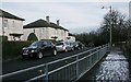
Crosslees Drive
Road with a steep incline in Thornliebank.
Image: © Stephen Sweeney
Taken: 13 Jun 2009
0.08 miles
3

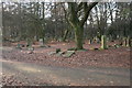
Eastwood New Cemetery
Looking along one of the roads in the cemetery. The trees have been allowed to grow throughout the cemetery, and over the years parts of it have changed from an open area to a wood.
The cemetery contains Commonwealth War Graves.
Photographed on a frosty January day.
Image: © Richard Sutcliffe
Taken: 5 Jan 2017
0.10 miles
4
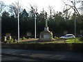
War memorial in Thornliebank
At the junction of Thornliebank Road and Bangorshill Street.
Image: © Stephen Sweeney
Taken: 13 Jun 2009
0.11 miles
6
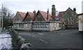
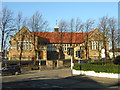
Thornliebank Primary School
Seen from Bangorshill Street. The school is a Category B listed building.
Image: © Richard Sutcliffe
Taken: 13 Jan 2017
0.13 miles
8
Eastwood New Cemetery
A graveyard in a wood. The trees have been allowed to grow throughout the cemetery, and over the years parts of it have changed from an open area to a wood. It must be a very gloomy place when the leaves are on the trees.
The cemetery contains Commonwealth War Graves.
Image: © Richard Sutcliffe
Taken: 5 Jan 2017
0.14 miles
9

Thornliebank Primary School
Seen from Bangorshill Street.
Image: © Richard Sutcliffe
Taken: 13 Jan 2017
0.14 miles
10
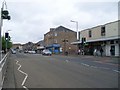
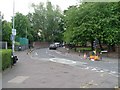
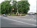
Thornliebank Main Street
Looking in the direction to the roundabout at Rouken Glen Road.
Image: © Stephen Sweeney
Taken: 13 Jun 2009
0.16 miles