IMAGES TAKEN NEAR TO
Neidpath Road East, GLASGOW, G46 6TX
Introduction
This page details the photographs taken nearby to Neidpath Road East, G46 6TX by members of the Geograph project.
The Geograph project started in 2005 with the aim of publishing, organising and preserving representative images for every square kilometre of Great Britain, Ireland and the Isle of Man.

There are currently over 7.5m images from over14,400 individuals and you can help contribute to the project by visiting https://www.geograph.org.uk
Image Map
Images are licensed for reuse under creativecommons.org/licenses/by-sa/2.0
Notes
- Clicking on the map will re-center to the selected point.
- The higher the marker number, the further away the image location is from the centre of the postcode.
Image Listing (8 Images Found)
Images are licensed for reuse under creativecommons.org/licenses/by-sa/2.0
Image
Details
Distance
4
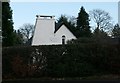
Sundial on a house
An unusual chimney, together with the sundial, make this house on Broom Road very distinctive.
Image: © Richard Sutcliffe
Taken: 10 Dec 2018
0.18 miles
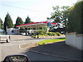
5
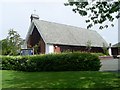
Broom Parish Church of Scotland
On Mearns Road at Broom Road East.
Image: © Stephen Sweeney
Taken: 29 Jul 2009
0.23 miles
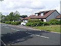
6
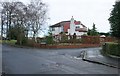
House at corner of Falkland Avenue and Dunvegan Drive
Image: © Richard Sutcliffe
Taken: 10 Dec 2018
0.23 miles
7
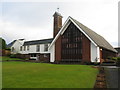
Broom Parish Church of Scotland
In Newton Mearns at the corner of Mearns Road and Broom Road East.
Image: © G Laird
Taken: 1 Jan 2013
0.24 miles
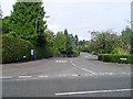
8
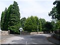
Private road to Whitecraigs Bowling Club
Everything around this area seemed to be private!
Image: © Stephen Sweeney
Taken: 29 Jul 2009
0.25 miles