IMAGES TAKEN NEAR TO
Roddinghead Road, GLASGOW, G46 6TP
Introduction
This page details the photographs taken nearby to Roddinghead Road, G46 6TP by members of the Geograph project.
The Geograph project started in 2005 with the aim of publishing, organising and preserving representative images for every square kilometre of Great Britain, Ireland and the Isle of Man.

There are currently over 7.5m images from over14,400 individuals and you can help contribute to the project by visiting https://www.geograph.org.uk
Image Map
Images are licensed for reuse under creativecommons.org/licenses/by-sa/2.0
Notes
- Clicking on the map will re-center to the selected point.
- The higher the marker number, the further away the image location is from the centre of the postcode.
Image Listing (7 Images Found)
Images are licensed for reuse under creativecommons.org/licenses/by-sa/2.0
Image
Details
Distance
2
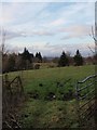
Field beside the Mearns Road
The picture looks north. Beyond the field Cathcart Castle golf course can be spotted. The view north, extending to the Campsies and, visibility allowing, more distant hills, is typical of the more elevated locations to the south of Glasgow.
Image: © Alec MacKinnon
Taken: 17 Feb 2018
0.22 miles
5
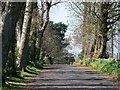
Drive running north west from Greenbank House
Image: © Elliott Simpson
Taken: 23 Apr 2015
0.23 miles
6
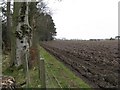
Freshly ploughed field near Clarkston
A view from the edge of the woodland at the edge of the Greenbank Gardens' policies.
Image: © M J Richardson
Taken: 6 Apr 2009
0.24 miles
7
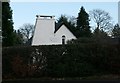
Sundial on a house
An unusual chimney, together with the sundial, make this house on Broom Road very distinctive.
Image: © Richard Sutcliffe
Taken: 10 Dec 2018
0.24 miles