IMAGES TAKEN NEAR TO
Mains Avenue, GLASGOW, G46 6QY
Introduction
This page details the photographs taken nearby to Mains Avenue, G46 6QY by members of the Geograph project.
The Geograph project started in 2005 with the aim of publishing, organising and preserving representative images for every square kilometre of Great Britain, Ireland and the Isle of Man.

There are currently over 7.5m images from over14,400 individuals and you can help contribute to the project by visiting https://www.geograph.org.uk
Image Map
Images are licensed for reuse under creativecommons.org/licenses/by-sa/2.0
Notes
- Clicking on the map will re-center to the selected point.
- The higher the marker number, the further away the image location is from the centre of the postcode.
Image Listing (21 Images Found)
Images are licensed for reuse under creativecommons.org/licenses/by-sa/2.0
Image
Details
Distance
4
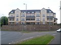
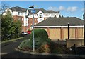
Flats on Ayr Road
Actually the back of flats on Mains Avenue.
Image: © Stephen Sweeney
Taken: 13 Jun 2009
0.07 miles
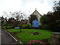
6
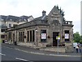
Bar Milano
Italian restaurant in a former Bank of Scotland building in Giffnock, south of Glasgow.
Image: © Stephen Sweeney
Taken: 13 Jun 2009
0.08 miles
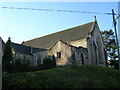
7
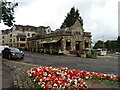
Banco Bar & Kitchen, Giffnock
Converted bank on Mains Avenue.
Image: © JThomas
Taken: 14 Sep 2021
0.09 miles
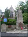
8
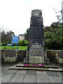
War Memorial near Giffnock South Parish Church
Image: © JThomas
Taken: 14 Sep 2021
0.09 miles
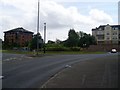
9
Roundabout on the A727, Giffnock
Junction with the A77.
Image: © JThomas
Taken: 14 Sep 2021
0.10 miles
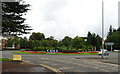
10
Eastwood Toll
Major roundabout in Eastwood, south of Glasgow.
Image: © Stephen Sweeney
Taken: 13 Jun 2009
0.11 miles