IMAGES TAKEN NEAR TO
Drakemire Drive, GLASGOW, G45 9SR
Introduction
This page details the photographs taken nearby to Drakemire Drive, G45 9SR by members of the Geograph project.
The Geograph project started in 2005 with the aim of publishing, organising and preserving representative images for every square kilometre of Great Britain, Ireland and the Isle of Man.

There are currently over 7.5m images from over14,400 individuals and you can help contribute to the project by visiting https://www.geograph.org.uk
Image Map
Images are licensed for reuse under creativecommons.org/licenses/by-sa/2.0
Notes
- Clicking on the map will re-center to the selected point.
- The higher the marker number, the further away the image location is from the centre of the postcode.
Image Listing (9 Images Found)
Images are licensed for reuse under creativecommons.org/licenses/by-sa/2.0
Image
Details
Distance
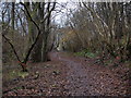
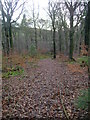
2
North entrance to Castlemilk Woodlands
The woodlands and the path through them are on the edge of the Castlemilk housing scheme on the south edge of Glasgow.
Image: © Alec MacKinnon
Taken: 14 Dec 2014
0.07 miles
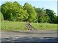
3
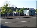
Headstones for sale
Lainshaw Drive, Castlemilk.
Image: © Stephen Sweeney
Taken: 12 May 2009
0.09 miles
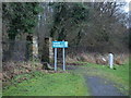
4
Linn Park pathway
This maintained path to a southern entrance of Linn Park is unmarked on current Ordnance Survey mapping.
Image: © Mark Nightingale
Taken: 3 Dec 2009
0.10 miles
5
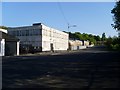
Drakemire Drive
Mainly industrial street in the west of Castlemilk.
Image: © Stephen Sweeney
Taken: 12 May 2009
0.15 miles
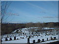
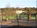
7
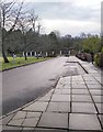
Linn Crematorium
The road leading away from the crematorium buildings.
Image: © Richard Sutcliffe
Taken: 17 Dec 2019
0.19 miles