IMAGES TAKEN NEAR TO
Shetland Drive, GLASGOW, G44 5DR
Introduction
This page details the photographs taken nearby to Shetland Drive, G44 5DR by members of the Geograph project.
The Geograph project started in 2005 with the aim of publishing, organising and preserving representative images for every square kilometre of Great Britain, Ireland and the Isle of Man.

There are currently over 7.5m images from over14,400 individuals and you can help contribute to the project by visiting https://www.geograph.org.uk
Image Map
Images are licensed for reuse under creativecommons.org/licenses/by-sa/2.0
Notes
- Clicking on the map will re-center to the selected point.
- The higher the marker number, the further away the image location is from the centre of the postcode.
Image Listing (14 Images Found)
Images are licensed for reuse under creativecommons.org/licenses/by-sa/2.0
Image
Details
Distance
1
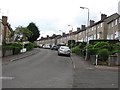
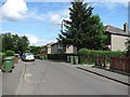
Elmore Avenue
A residential street in southern Glasgow (G44).
Image: © Richard Webb
Taken: 29 Jun 2011
0.13 miles
2
Carmunnock Road
A speed camera on Carmunnock Road, a busy route into/out of Glasgow.
Image: © Richard Webb
Taken: 29 Jun 2011
0.14 miles
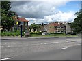
3
Carmunnock Road
Carmunnock Road passing King's Park.
Image: © Richard Webb
Taken: 29 Jun 2011
0.16 miles
4
King's Park
The marquee and gazebos in the distance are just being taken down following a 'Wild in the City' event, run by the Council's Countryside Ranger Service.
Image: © Richard Sutcliffe
Taken: 5 Jul 2017
0.17 miles
5
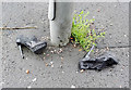
Abandoned black stiletto shoes
Unknown brand black platform stileto shoes with an exceptionally high heel, abandoned on Carmunnock Road, near the roundabout at Croftfoot Road.
Image: © Thomas Nugent
Taken: 19 Aug 2017
0.19 miles
6
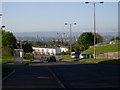
North view across Glasgow from Carmunnock Road
View over Glasgow from Castlemilk.
Image: © Stephen Sweeney
Taken: 12 May 2009
0.20 miles
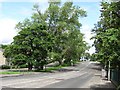
7
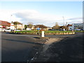
Roundabout on Carmunnock Road (B766)
Looking along Drakemire Drive to the roundabout. Carmunnock Road runs both left and right at the roundabout while Croftfoot Road exits the roundabout at the far side. A branch of Lloyds TSB Scotland is the white building at the far right hand side of the roundabout.
Image: © G Laird
Taken: 27 Nov 2012
0.20 miles
8
Thornicroft Drive, Croftfoot
Residential street in the south of Glasgow.
Image: © Richard Webb
Taken: 29 Jun 2011
0.22 miles
9
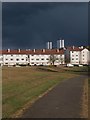
Drakemire Drive with threatening sky
The path in the foreground runs across the grassy area between Simshill Road (behind the photographer) and Drakemire Drive. The scary looking sky eventually fulfilled its promise, delivering a hail shower a couple of hours later.
Image: © Alec MacKinnon
Taken: 6 May 2012
0.22 miles
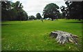
10
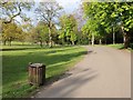
Scene in King's Park
When I first came to Glasgow I was told that it has the most green space per head of population of all UK cities. I don't know if that's true but there are 90+ parks and gardens. King's Park is one of them, offering a pleasant space for the surrounding residential areas of Simshill, Castlemilk, Croftfoot and indeed King's Park.
Image: © Alec MacKinnon
Taken: 6 May 2012
0.23 miles