IMAGES TAKEN NEAR TO
Farne Drive, GLASGOW, G44 5DL
Introduction
This page details the photographs taken nearby to Farne Drive, G44 5DL by members of the Geograph project.
The Geograph project started in 2005 with the aim of publishing, organising and preserving representative images for every square kilometre of Great Britain, Ireland and the Isle of Man.

There are currently over 7.5m images from over14,400 individuals and you can help contribute to the project by visiting https://www.geograph.org.uk
Image Map
Images are licensed for reuse under creativecommons.org/licenses/by-sa/2.0
Notes
- Clicking on the map will re-center to the selected point.
- The higher the marker number, the further away the image location is from the centre of the postcode.
Image Listing (11 Images Found)
Images are licensed for reuse under creativecommons.org/licenses/by-sa/2.0
Image
Details
Distance
1
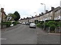
Elmore Avenue
A residential street in southern Glasgow (G44).
Image: © Richard Webb
Taken: 29 Jun 2011
0.14 miles
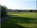
2
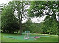
Play apparatus, Linn Park
Linn Park (73Ha) is the second largest park in Glasgow, according to the Council. (There may be other bigger ones looked after by the other local authorities). It is well wooded.
Image: © Richard Webb
Taken: 29 Jun 2011
0.18 miles
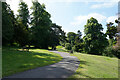
3
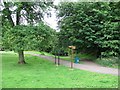
Linn Park
Paths in the second largest park in Glasgow City Council's area (according to their website).
Image: © Richard Webb
Taken: 29 Jun 2011
0.19 miles
4
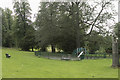
Children's play area
At the top of Linn Park is this small play area for young children.
Image: © Malcolm Neal
Taken: 22 Aug 2018
0.20 miles
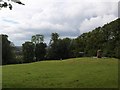
5
The north end of Linn Park
On a summers day after the schools have broken up the park is surprisingly quiet this morning.
Image: © Malcolm Neal
Taken: 29 Jun 2021
0.20 miles
6
Court Knowe monument
The Battle of Langside on 12 May 1568 is commemorated in the Battlefield monument (Image). Mary Queen of Scots did not, of course, take part in the battle personally, but watched the defeat of her supporters from a nearby eminence, believed to be here on Court Knowe. The monument commemorates the unfortunate monarch's presence on that day.
Image: © Alec MacKinnon
Taken: 19 Jun 2011
0.21 miles
8
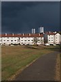
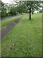
Drakemire Drive with threatening sky
The path in the foreground runs across the grassy area between Simshill Road (behind the photographer) and Drakemire Drive. The scary looking sky eventually fulfilled its promise, delivering a hail shower a couple of hours later.
Image: © Alec MacKinnon
Taken: 6 May 2012
0.23 miles
9
Simshill Road approaching Linn Park Golf Club
Simshill Road climbs uphill to the entrance to Linn Park at the golf club. The actual course is on the behind the hedge on the left-hand side of the picture but a couple of presumably stray golf balls in the grass hint at its presence. Simshill road is traffic calmed at this point and there is a good path for pedestrians.
Image: © Alec MacKinnon
Taken: 19 Jun 2011
0.23 miles
10
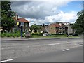
Carmunnock Road
A speed camera on Carmunnock Road, a busy route into/out of Glasgow.
Image: © Richard Webb
Taken: 29 Jun 2011
0.24 miles