IMAGES TAKEN NEAR TO
Kingsacre Road, GLASGOW, G44 4LP
Introduction
This page details the photographs taken nearby to Kingsacre Road, G44 4LP by members of the Geograph project.
The Geograph project started in 2005 with the aim of publishing, organising and preserving representative images for every square kilometre of Great Britain, Ireland and the Isle of Man.

There are currently over 7.5m images from over14,400 individuals and you can help contribute to the project by visiting https://www.geograph.org.uk
Image Map
Images are licensed for reuse under creativecommons.org/licenses/by-sa/2.0
Notes
- Clicking on the map will re-center to the selected point.
- The higher the marker number, the further away the image location is from the centre of the postcode.
Image Listing (5 Images Found)
Images are licensed for reuse under creativecommons.org/licenses/by-sa/2.0
Image
Details
Distance
1
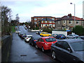
Kingsbridge Drive
Looking towards Kings Park Primary School from the entrance to Kings Park railway station.
Image: © Thomas Nugent
Taken: 29 Dec 2012
0.21 miles
2
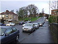
Kingsbridge Drive
Looking towards Kings Park Primary School from the bridge at Kings Park railway station.
Image: © Thomas Nugent
Taken: 29 Dec 2012
0.21 miles
3
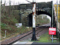
Kings Park railway station
Looking east to one of the arches of the Kingsbridge Drive bridge.
Image: © Thomas Nugent
Taken: 29 Dec 2012
0.25 miles
4
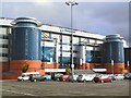
Hampden Park
The Scottish National Football Stadium at Mount Florida, Glasgow.
Image: © Roger May
Taken: 8 Sep 2005
0.25 miles
5
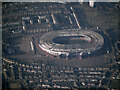
Hampden Park Stadium from the air
The national stadium, viewed from 11,000 feet above Clarkston from a Prague bound flight from Glasgow.
Ten seconds later, Celtic Park Image
Image: © Thomas Nugent
Taken: 27 Mar 2022
0.25 miles