IMAGES TAKEN NEAR TO
Castlemilk Road, GLASGOW, G44 4LE
Introduction
This page details the photographs taken nearby to Castlemilk Road, G44 4LE by members of the Geograph project.
The Geograph project started in 2005 with the aim of publishing, organising and preserving representative images for every square kilometre of Great Britain, Ireland and the Isle of Man.

There are currently over 7.5m images from over14,400 individuals and you can help contribute to the project by visiting https://www.geograph.org.uk
Image Map (Loading...)


Getting Data...Please wait
Leaflet Map data © OpenStreetMap
Images are licensed for reuse under creativecommons.org/licenses/by-sa/2.0
Notes
- Clicking on the map will re-center to the selected point.
- The higher the marker number, the further away the image location is from the centre of the postcode.
Image Listing (12 Images Found)
Images are licensed for reuse under creativecommons.org/licenses/by-sa/2.0
Image
Details
Distance
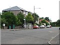
2
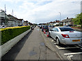
King's Park Avenue
Parked cars as far as the eye can see.
Image: © Thomas Nugent
Taken: 27 May 2017
0.11 miles
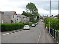
3
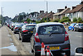
King's Park Avenue
Parked cars on both sides of the road as far as the eye can see.
Image: © Thomas Nugent
Taken: 27 May 2017
0.11 miles
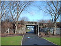
5
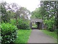
Underpass, King's Park
A bridge carries the railway over a path linking Castlemilk Road with King's Park and its shopping centre.
Image: © Richard Webb
Taken: 29 Jun 2011
0.14 miles
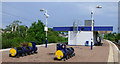
8
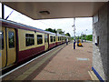
Barry The Barrel at Croftfoot railway station
An old liveried Scotrail Class 314 train heading west to Glasgow Central.
Image: © Thomas Nugent
Taken: 27 May 2017
0.24 miles
9
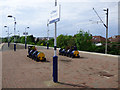
Croftfoot railway station
Two 'Barry The Barrel' planters at the west end of the island platform.
Image: © Thomas Nugent
Taken: 27 May 2017
0.24 miles
10
Croftfoot railway station
Two 'Barry The Barrel' planters at the west end of the island platform. The station is on the Newton branch of the Cathcart Circle, between Kings Park and Burnside stations.
Image: © Thomas Nugent
Taken: 27 May 2017
0.24 miles