IMAGES TAKEN NEAR TO
Ruel Street, GLASGOW, G44 4AP
Introduction
This page details the photographs taken nearby to Ruel Street, G44 4AP by members of the Geograph project.
The Geograph project started in 2005 with the aim of publishing, organising and preserving representative images for every square kilometre of Great Britain, Ireland and the Isle of Man.

There are currently over 7.5m images from over14,400 individuals and you can help contribute to the project by visiting https://www.geograph.org.uk
Image Map
Images are licensed for reuse under creativecommons.org/licenses/by-sa/2.0
Notes
- Clicking on the map will re-center to the selected point.
- The higher the marker number, the further away the image location is from the centre of the postcode.
Image Listing (41 Images Found)
Images are licensed for reuse under creativecommons.org/licenses/by-sa/2.0
Image
Details
Distance
1
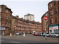
Cathcart Road at Holmlea Road
The picture looks across Holmlea Road into Cathcart, at the end of its serpentine progress south from the Gorbals.
Image: © Alec MacKinnon
Taken: 8 Aug 2015
0.07 miles
2
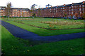
Park at Orchy Street
Holmlea Road is to the right, with Gryffe Street on the left.
Image: © Thomas Nugent
Taken: 30 Oct 2010
0.12 miles
3
Park at Orchy Street
Gryffe Street tenements are visible on the right.
Image: © Thomas Nugent
Taken: 30 Oct 2010
0.13 miles
4
Holmlea Road
Viewed from Orchy Street.
Image: © Thomas Nugent
Taken: 30 Oct 2010
0.13 miles
5
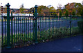
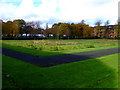
Park at Orchy Street
The spikes on top of the fence and gate have been cut off, probably as a safety measure.
Image: © Thomas Nugent
Taken: 30 Oct 2010
0.14 miles
6
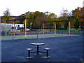
Park at Orchy Street
Good quality old fashioned swings with cast iron brackets and cross members survive in the 21st century.
Image: © Thomas Nugent
Taken: 30 Oct 2010
0.14 miles
7
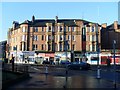
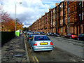
Glasgow tenements
At the corner of Battlefield Road and Holmlea Road.
Image: © Stephen Sweeney
Taken: 28 Jan 2009
0.14 miles
8

Park at Orchy Street
part of the park is being used as a construction site.
Image: © Thomas Nugent
Taken: 30 Oct 2010
0.14 miles
9

Spean Street
What appears to be flood prevention work under way at White Cart Water which is between the wall and the blue machine.
Image: © Thomas Nugent
Taken: 30 Oct 2010
0.15 miles
10
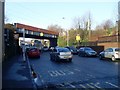
Railway bridge at Mount Florida Station
Over Battlefield Road.
Image: © Stephen Sweeney
Taken: 28 Jan 2009
0.15 miles