IMAGES TAKEN NEAR TO
Voil Drive, GLASGOW, G44 3YY
Introduction
This page details the photographs taken nearby to Voil Drive, G44 3YY by members of the Geograph project.
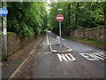
The Geograph project started in 2005 with the aim of publishing, organising and preserving representative images for every square kilometre of Great Britain, Ireland and the Isle of Man.

There are currently over 7.5m images from over14,400 individuals and you can help contribute to the project by visiting https://www.geograph.org.uk
Image Map
Images are licensed for reuse under creativecommons.org/licenses/by-sa/2.0
Notes
- Clicking on the map will re-center to the selected point.
- The higher the marker number, the further away the image location is from the centre of the postcode.
Image Listing (33 Images Found)
Images are licensed for reuse under creativecommons.org/licenses/by-sa/2.0
Image
Details
Distance
1
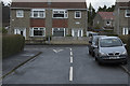
The end of Lochinver Drive
The T junction at the end of the road
Image: © Malcolm Neal
Taken: 2 Feb 2017
0.06 miles
2
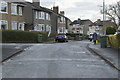
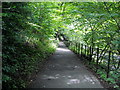
Lochinver Drive Cathcart
Looking along a typical street in Glasgow
Image: © Malcolm Neal
Taken: 2 Feb 2017
0.06 miles
3
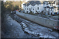
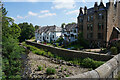
White Cart Water Flood Prevention
The concrete wall is now almost complete protecting the row of white painted houses from what was fairly frequent flooding.
Image: © Malcolm Neal
Taken: 1 Feb 2019
0.09 miles
4
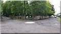
Mini-roundabout on Netherlee Road
Netherlee Road meets Brenfield Road at this mini-roundabout. Netherlee Road splits Cathcart Cemetery in two and a gate into the northern section lies behind.
Image: © Alec MacKinnon
Taken: 19 Jun 2011
0.10 miles
5
Netherlee Road
Netherlee Road used to provide a short-cut from Clarkston Road for some traffic heading north into the city. For many years it has been impossible to turn into it from Clarkston road (Image). As shown here, it is also closed to south-heading traffic where it meets Brenfield Road.
Image: © Alec MacKinnon
Taken: 19 Jun 2011
0.11 miles
8
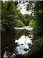
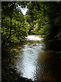
From the Snuff Mill Bridge
The view shows the completed flood defences with the river at its lowest. When in flood it reaches just below the top of the flood prevention wall.
Image: © Malcolm Neal
Taken: 29 Jun 2021
0.12 miles
10
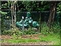
Waste water pumping station
Beside Millholm Road. Operated by Scottish Water.
Image: © Richard Sutcliffe
Taken: 14 Jul 2023
0.13 miles