IMAGES TAKEN NEAR TO
Deanwood Avenue, GLASGOW, G44 3RJ
Introduction
This page details the photographs taken nearby to Deanwood Avenue, G44 3RJ by members of the Geograph project.
The Geograph project started in 2005 with the aim of publishing, organising and preserving representative images for every square kilometre of Great Britain, Ireland and the Isle of Man.

There are currently over 7.5m images from over14,400 individuals and you can help contribute to the project by visiting https://www.geograph.org.uk
Image Map
Images are licensed for reuse under creativecommons.org/licenses/by-sa/2.0
Notes
- Clicking on the map will re-center to the selected point.
- The higher the marker number, the further away the image location is from the centre of the postcode.
Image Listing (55 Images Found)
Images are licensed for reuse under creativecommons.org/licenses/by-sa/2.0
Image
Details
Distance
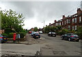
1
Deanwood Avenue / Deanwood Road, G44
Shows the location of Image
Image: © Mike Quinn
Taken: 21 Oct 2010
0.02 miles
2
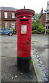
Edward VIII postbox on Deanwood Avenue
Image: © JThomas
Taken: 14 Sep 2021
0.02 miles
3
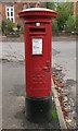
Edward VIII postbox, Deanwood Avenue / Deanwood Road, G44
Image: © Mike Quinn
Taken: 21 Oct 2010
0.02 miles
4
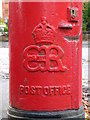
Edward VIII postbox, Deanwood Avenue / Deanwood Road, G44 - royal cipher
See Image
Image: © Mike Quinn
Taken: 21 Oct 2010
0.02 miles

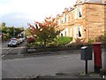
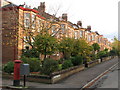
6

Houses on Deanwood Avenue
Showing position of Postbox No. G44 1045.
See Image] for postbox.
Image: © JThomas
Taken: 14 Sep 2021
0.03 miles
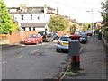
7
Deanwood Avenue
Showing position of Postbox No. G44 1045.
See Image] for postbox.
Image: © JThomas
Taken: 14 Sep 2021
0.04 miles
8
Houses in Deanwood Avenue, G44 (2)
Shows the location of Image
Image: © Mike Quinn
Taken: 21 Oct 2010
0.04 miles
10
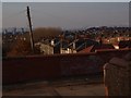
End of lane on Parklands Road
The photo is taken from the end of the lane between Ormonde Drive and Ormonde Crescent, where it meets Parklands Road. The brick wall on the other side of Parklands Road fell down a few months ago so the rebuilt version still looks very new.
Image: © Alec MacKinnon
Taken: 7 Mar 2010
0.15 miles