IMAGES TAKEN NEAR TO
Netherlee Road, GLASGOW, G44 3QB
Introduction
This page details the photographs taken nearby to Netherlee Road, G44 3QB by members of the Geograph project.
The Geograph project started in 2005 with the aim of publishing, organising and preserving representative images for every square kilometre of Great Britain, Ireland and the Isle of Man.

There are currently over 7.5m images from over14,400 individuals and you can help contribute to the project by visiting https://www.geograph.org.uk
Image Map
Images are licensed for reuse under creativecommons.org/licenses/by-sa/2.0
Notes
- Clicking on the map will re-center to the selected point.
- The higher the marker number, the further away the image location is from the centre of the postcode.
Image Listing (44 Images Found)
Images are licensed for reuse under creativecommons.org/licenses/by-sa/2.0
Image
Details
Distance
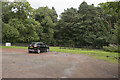
3
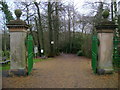
Western entrance to Linn Park
This driveway leads to a footbridge across White Cart Water. The vast majority of the park is east of the river.
Image: © Mark Nightingale
Taken: 3 Dec 2009
0.10 miles
4
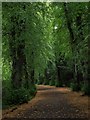
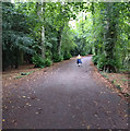
Path leading into Linn Park
People entering Linn Park from Clarkston Road (Image) pass along this avenue. Although the trees are still mostly green, at the start of September the leaves are beginning to fall.
Image: © Alec MacKinnon
Taken: 7 Sep 2013
0.10 miles
5
Linn Park
A path through part of the park.
Image: © Malcolm Neal
Taken: 21 Aug 2018
0.10 miles
7
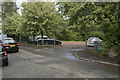
An entrance to Linn Park
Just out of view is a play centre, but it appears only to be open during school hours, but is now open to everyone.
Image: © Malcolm Neal
Taken: 23 Aug 2018
0.12 miles
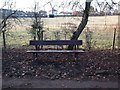
8
The car park
A single car in the car park for the closed play centre / play ground.
Image: © Malcolm Neal
Taken: 23 Aug 2018
0.12 miles
9
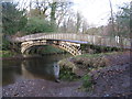
The White Bridge, Linn Park
Footbridge spanning the White Cart Water just up river from the waterfall.
Image: © G Laird
Taken: 27 Nov 2012
0.13 miles
10
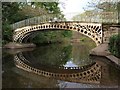
Bridge over the White Cart
The bridge is viewed here from a little beach just to its south, on the other side from the view shown in Image Since it is just upstream from the waterfall (Image) and not far from the Clarkston Road entrance (Image) it sees lots of traffic from the Park's visitors. The river is not usually quite as tranquil as it was this afternoon.
Image: © Alec MacKinnon
Taken: 6 May 2012
0.13 miles