IMAGES TAKEN NEAR TO
Oakley Drive, GLASGOW, G44 3PY
Introduction
This page details the photographs taken nearby to Oakley Drive, G44 3PY by members of the Geograph project.
The Geograph project started in 2005 with the aim of publishing, organising and preserving representative images for every square kilometre of Great Britain, Ireland and the Isle of Man.

There are currently over 7.5m images from over14,400 individuals and you can help contribute to the project by visiting https://www.geograph.org.uk
Image Map
Images are licensed for reuse under creativecommons.org/licenses/by-sa/2.0
Notes
- Clicking on the map will re-center to the selected point.
- The higher the marker number, the further away the image location is from the centre of the postcode.
Image Listing (51 Images Found)
Images are licensed for reuse under creativecommons.org/licenses/by-sa/2.0
Image
Details
Distance
1
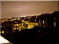
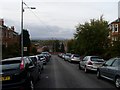
Night view over Glasgow's East End
From Ormonde Crescent, Williamwood.
Image: © Stephen Sweeney
Taken: 26 Dec 2007
0.06 miles
2
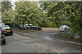
An entrance to Linn Park
Just out of view is a play centre, but it appears only to be open during school hours, but is now open to everyone.
Image: © Malcolm Neal
Taken: 23 Aug 2018
0.10 miles
3
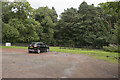
The car park
A single car in the car park for the closed play centre / play ground.
Image: © Malcolm Neal
Taken: 23 Aug 2018
0.12 miles

6
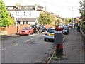
Bute gardens
Bute gardens is a cul-de-sac off Clarkston Road. It is a cull-de-sac because it ends at the walls of the very large Cathcart Cemetery
Image: © Malcolm Neal
Taken: 5 May 2018
0.14 miles
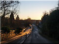
7
Ormonde Crescent, Williamwood
Looking back towards the City Centre of Glasgow from an area in the southeast, just off Clarkston Road.
Image: © Stephen Sweeney
Taken: 12 Oct 2008
0.15 miles
8
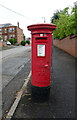
George V postbox on Parklands Road
Postbox No. G44 735.
Image: © JThomas
Taken: 14 Sep 2021
0.15 miles
10
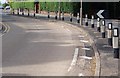
Netherlee Road passing through Cathcart Cemetery
The picture looks southwest along Netherlee Road. This street is one-way for cars, which may not enter at its north end (behind the photographer). Cyclists may however use the cycle lane to the left of the road in this picture. Cathcart Cemetery occupies the space to either side of the road.
Image: © Alec MacKinnon
Taken: 2 Jan 2021
0.16 miles