IMAGES TAKEN NEAR TO
Muirhill Avenue, GLASGOW, G44 3HS
Introduction
This page details the photographs taken nearby to Muirhill Avenue, G44 3HS by members of the Geograph project.
The Geograph project started in 2005 with the aim of publishing, organising and preserving representative images for every square kilometre of Great Britain, Ireland and the Isle of Man.

There are currently over 7.5m images from over14,400 individuals and you can help contribute to the project by visiting https://www.geograph.org.uk
Image Map
Images are licensed for reuse under creativecommons.org/licenses/by-sa/2.0
Notes
- Clicking on the map will re-center to the selected point.
- The higher the marker number, the further away the image location is from the centre of the postcode.
Image Listing (80 Images Found)
Images are licensed for reuse under creativecommons.org/licenses/by-sa/2.0
Image
Details
Distance
1
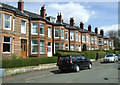
Cairndow Avenue
Looking towards Clarkston Road from Muirend Avenue.
Image: © Thomas Nugent
Taken: 27 Apr 2013
0.10 miles

3
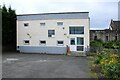
No 100 the gateway
Next door to Cathcart Baptist Church. Part of the Cathcart Youth Ministry Partnership, it operates an after school drop-in for young people at secondary school.
Image: © Richard Sutcliffe
Taken: 13 Jul 2024
0.11 miles
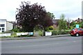
4

Largie Road
Looking down the shorter side of Largie road across Merrylee road to the longer Largie road on the other side.
Image: © David Nicol
Taken: 28 Aug 2004
0.12 miles
5

Church signs
At Cathcart Baptist Church on Merrylee Road.
Image: © Richard Sutcliffe
Taken: 13 Jul 2024
0.12 miles
6
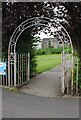
Entrance to Cathcart Baptist Church
On Merrylee Road.
Image: © Richard Sutcliffe
Taken: 13 Jul 2024
0.12 miles
7
Entrance to Cathcart Baptist Church
On Merrylee Road.
Image: © Richard Sutcliffe
Taken: 13 Jul 2024
0.12 miles
8
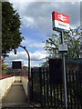
Muirend railway station
The Whitemoss Avenue entrance to the station.
Image: © Thomas Nugent
Taken: 27 Apr 2013
0.12 miles
9
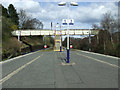
Muirend railway station
The steps leading to the footbridge between Whitemooss Avenue and Cairndow Court.
Image: © Thomas Nugent
Taken: 27 Apr 2013
0.13 miles
10
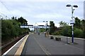
Muirend Station
Looking towards the footbridge at the northern end of the island platform at the station, which is Category B listed https://portal.historicenvironment.scot/designation/LB33942.
Image: © Richard Sutcliffe
Taken: 13 Jul 2024
0.13 miles