IMAGES TAKEN NEAR TO
Hillcrest Avenue, GLASGOW, G44 3ET
Introduction
This page details the photographs taken nearby to Hillcrest Avenue, G44 3ET by members of the Geograph project.
The Geograph project started in 2005 with the aim of publishing, organising and preserving representative images for every square kilometre of Great Britain, Ireland and the Isle of Man.

There are currently over 7.5m images from over14,400 individuals and you can help contribute to the project by visiting https://www.geograph.org.uk
Image Map
Images are licensed for reuse under creativecommons.org/licenses/by-sa/2.0
Notes
- Clicking on the map will re-center to the selected point.
- The higher the marker number, the further away the image location is from the centre of the postcode.
Image Listing (70 Images Found)
Images are licensed for reuse under creativecommons.org/licenses/by-sa/2.0
Image
Details
Distance
1
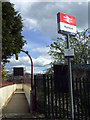
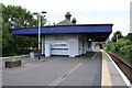
Muirend railway station
The Whitemoss Avenue entrance to the station.
Image: © Thomas Nugent
Taken: 27 Apr 2013
0.08 miles
2
Muirend Station
Looking towards the footbridge at the northern end of the island platform at the station, which is Category B listed https://portal.historicenvironment.scot/designation/LB33942.
Image: © Richard Sutcliffe
Taken: 13 Jul 2024
0.08 miles
3
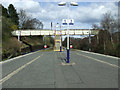
Muirend railway station
The steps leading to the footbridge between Whitemooss Avenue and Cairndow Court.
Image: © Thomas Nugent
Taken: 27 Apr 2013
0.09 miles
4
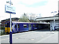
Muirend railway station
Class 314 train number 314 208 is heading for Neilston.
Image: © Thomas Nugent
Taken: 27 Apr 2013
0.10 miles
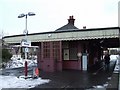
5
Muirend Station
The ticket office and waiting room of the station, which was built by the Lanarkshire & Ayrshire Railway about 1903.
It is Category B listed https://portal.historicenvironment.scot/designation/LB33942.
Image: © Richard Sutcliffe
Taken: 13 Jul 2024
0.10 miles
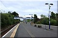
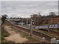
6

Muirend train station, platform 2
Trains from Glasgow Central arrive at platform 2, heading on towards the end of the line at Neilston. The picture looks roughly north, in the direction the trains arrive from.
Image: © Alec MacKinnon
Taken: 17 Feb 2013
0.10 miles
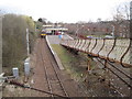
7
Muirend train station
Last year Network Rail decided to fell trees along the Neilston and East Kilbride railway lines in the south of Glasgow. As a result Muirend train station, for example, is now seen much more clearly from the surrounding streets (cf. Image). The tree felling was not completely uncontroversial, however, e.g. https://www.glasgowsouthandeastwoodextra.co.uk/news/giffnock-residents-cut-tree-chopping-2515371
Image: © Alec MacKinnon
Taken: 4 Apr 2020
0.10 miles
8
Muirend railway station
A typical Glasgow south side station with a single island platform with chalet style building and canopy.
Image: © Thomas Nugent
Taken: 30 Dec 2009
0.10 miles
9
Muirend railway station, Glasgow
Opened in 1903 by the Lanarkshire and Ayrshire Railway on the line from Glasgow and Newton to Ardrossan. Since 1964, the line has only gone as far west as Neilston. View north east towards Cathcart and Glasgow.
Image: © Nigel Thompson
Taken: 26 Mar 2011
0.10 miles
10

Muirend railway station
The station building is a Category B Listed structure, described by Historic Scotland as follows...
Style of James Millar. Late 19th/early 20th century. Station with Art Nouveau detailing, free standing on island platform, and with deep cantilevered flat canopy, decorative timber valance with pierced heart ornament. Red brick and timber, small-paned openings, slated main roof with red ridging, deep-corniced brick axial stacks; distinctive aedicular notice boards.
Image: © Thomas Nugent
Taken: 27 Apr 2013
0.11 miles