IMAGES TAKEN NEAR TO
Windhill Crescent, GLASGOW, G43 2UP
Introduction
This page details the photographs taken nearby to Windhill Crescent, G43 2UP by members of the Geograph project.
The Geograph project started in 2005 with the aim of publishing, organising and preserving representative images for every square kilometre of Great Britain, Ireland and the Isle of Man.

There are currently over 7.5m images from over14,400 individuals and you can help contribute to the project by visiting https://www.geograph.org.uk
Image Map
Images are licensed for reuse under creativecommons.org/licenses/by-sa/2.0
Notes
- Clicking on the map will re-center to the selected point.
- The higher the marker number, the further away the image location is from the centre of the postcode.
Image Listing (9 Images Found)
Images are licensed for reuse under creativecommons.org/licenses/by-sa/2.0
Image
Details
Distance
1
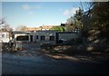
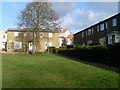
Brownhill Road housing
In Mansewood.
Image: © Stephen Sweeney
Taken: 25 Feb 2009
0.09 miles
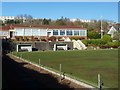
2
Looking towards Hillpark Secondary School
Along Nevis Road.
Image: © Stephen Sweeney
Taken: 25 Feb 2009
0.13 miles
3
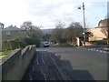
Looking south on Mansewood Road
Towards Burnfield Road.
Image: © Stephen Sweeney
Taken: 25 Feb 2009
0.13 miles
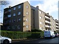
4
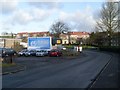
Mansewood and Merrylee
Residential areas in Glasgow.
Image: © Stephen Sweeney
Taken: 25 Feb 2009
0.13 miles
5
Houses on Burnfield Road
In Mansewood.
Image: © Stephen Sweeney
Taken: 25 Feb 2009
0.16 miles
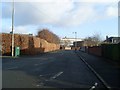
7
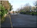
Traffic calming scheme on Mansewood Road
Outside Hillpark Secondary School.
Image: © Stephen Sweeney
Taken: 25 Feb 2009
0.21 miles