IMAGES TAKEN NEAR TO
Woodburn Road, GLASGOW, G43 2TN
Introduction
This page details the photographs taken nearby to Woodburn Road, G43 2TN by members of the Geograph project.
The Geograph project started in 2005 with the aim of publishing, organising and preserving representative images for every square kilometre of Great Britain, Ireland and the Isle of Man.

There are currently over 7.5m images from over14,400 individuals and you can help contribute to the project by visiting https://www.geograph.org.uk
Image Map
Images are licensed for reuse under creativecommons.org/licenses/by-sa/2.0
Notes
- Clicking on the map will re-center to the selected point.
- The higher the marker number, the further away the image location is from the centre of the postcode.
Image Listing (16 Images Found)
Images are licensed for reuse under creativecommons.org/licenses/by-sa/2.0
Image
Details
Distance
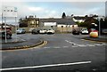
1
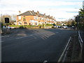
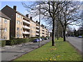
Crossroads in Newlands
Looking along Kilmarnock Road (A77) at the intersection with Nether Auldhouse Road (left) and Merrylee Road (right), both B762.
Image: © G Laird
Taken: 27 Nov 2012
0.08 miles
2
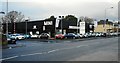
Car dealership
Harry Fairbairn car dealership on Kilmarnock Road. They specialise in selling Minis.
Image: © Richard Sutcliffe
Taken: 17 Dec 2019
0.17 miles
3
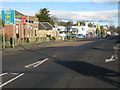
Welcome to Glasgow
The point where the A77 (Kilmarnock Road) leaves East Renfrewshire and enters Glasgow.
Image: © G Laird
Taken: 27 Nov 2012
0.20 miles
4
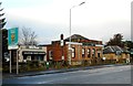
Wild Flours and United Dental Care
Gluten-free bakery and dental practice on Kilmarnock Road. The sign on the left marks the boundary between East Renfrewshire and City of Glasgow. The boundary itself follows a small burn which goes under the road at this point.
Image: © Richard Sutcliffe
Taken: 17 Dec 2019
0.20 miles
5
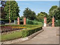
Kilmarnock Road entrance to Newlands Park
The Park sits in the middle of the suburb of Newlands. There are several small pedestrian entrances from the streets that bound it, plus these gates on the main thoroughfare of Kilmarnock Road.
Image: © Alec MacKinnon
Taken: 7 Jul 2013
0.20 miles
8
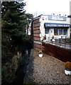
Bakery beside the burn
Wild Flours, a gluten-free bakery sits beside a small burn. The burn marks the boundary between East Renfrewshire and City of Glasgow.
Image: © Richard Sutcliffe
Taken: 17 Dec 2019
0.21 miles
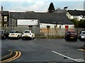
9
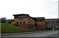
Merryvale Car park
Off Merryvale Place. The building behind was 'The Pet Place', a pet shop which is now closed.
Image: © Richard Sutcliffe
Taken: 17 Dec 2019
0.21 miles
10
The Pet Place
Rear of 'The Pet Place', a former pet shop on Fernleigh Road, which is now closed.
Image: © Richard Sutcliffe
Taken: 17 Dec 2019
0.21 miles