IMAGES TAKEN NEAR TO
Briar Grove, GLASGOW, G43 2TG
Introduction
This page details the photographs taken nearby to Briar Grove, G43 2TG by members of the Geograph project.
The Geograph project started in 2005 with the aim of publishing, organising and preserving representative images for every square kilometre of Great Britain, Ireland and the Isle of Man.

There are currently over 7.5m images from over14,400 individuals and you can help contribute to the project by visiting https://www.geograph.org.uk
Image Map
Images are licensed for reuse under creativecommons.org/licenses/by-sa/2.0
Notes
- Clicking on the map will re-center to the selected point.
- The higher the marker number, the further away the image location is from the centre of the postcode.
Image Listing (4 Images Found)
Images are licensed for reuse under creativecommons.org/licenses/by-sa/2.0
Image
Details
Distance
1
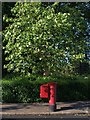
Postbox under a tree
The postbox sits on the north side of Calderwood Road, at its east end where it meets Lubnaig Road.
Image: © Alec MacKinnon
Taken: 7 Jul 2013
0.20 miles
2
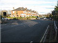
Crossroads in Newlands
Looking along Kilmarnock Road (A77) at the intersection with Nether Auldhouse Road (left) and Merrylee Road (right), both B762.
Image: © G Laird
Taken: 27 Nov 2012
0.23 miles
3
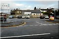
Merryvale Car park
Off Merryvale Place. The building behind was 'The Pet Place', a pet shop which is now closed.
Image: © Richard Sutcliffe
Taken: 17 Dec 2019
0.25 miles
4
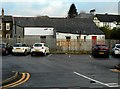
The Pet Place
Rear of 'The Pet Place', a former pet shop on Fernleigh Road, which is now closed.
Image: © Richard Sutcliffe
Taken: 17 Dec 2019
0.25 miles