IMAGES TAKEN NEAR TO
Lubnaig Road, GLASGOW, G43 2EB
Introduction
This page details the photographs taken nearby to Lubnaig Road, G43 2EB by members of the Geograph project.
The Geograph project started in 2005 with the aim of publishing, organising and preserving representative images for every square kilometre of Great Britain, Ireland and the Isle of Man.

There are currently over 7.5m images from over14,400 individuals and you can help contribute to the project by visiting https://www.geograph.org.uk
Image Map
Images are licensed for reuse under creativecommons.org/licenses/by-sa/2.0
Notes
- Clicking on the map will re-center to the selected point.
- The higher the marker number, the further away the image location is from the centre of the postcode.
Image Listing (32 Images Found)
Images are licensed for reuse under creativecommons.org/licenses/by-sa/2.0
Image
Details
Distance
1
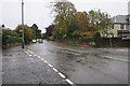
Newlands Road
Looking east from the junction with Lubnaig Road.
Image: © Richard Sutcliffe
Taken: 24 Oct 2015
0.07 miles
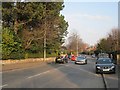
2
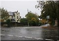
Lubnaig Road
Looking south from the junction with Newlands Road.
Image: © Richard Sutcliffe
Taken: 24 Oct 2015
0.07 miles
3
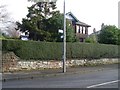
Streetname signs on Newlands Road
At the junction with St Bride's Road.
Image: © Stephen Sweeney
Taken: 25 Feb 2009
0.08 miles
4
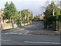
St Bride's Road
In Newlands, Glasgow.
Image: © Stephen Sweeney
Taken: 25 Feb 2009
0.10 miles
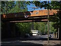
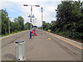
5
Langside railway station, Glasgow
Opened in 1894 by the Cathcart District Railway and today is part of the Cathcart Circle.
Langside Drive entrance.
Image: © Nigel Thompson
Taken: 19 Feb 2014
0.13 miles
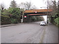
6
Railway bridge at Langside station
The bridge crosses Langside Drive and is viewed from the south. The station is just to the right of the photograph. Behind an antique bus awaits the guests at a wedding in Newlands South Church.
Image: © Alec MacKinnon
Taken: 25 May 2013
0.13 miles
7
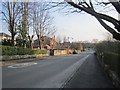
St Bride's Road
Newlands, buildings appeared on maps here in the early 20th century.
Image: © Richard Webb
Taken: 9 Apr 2013
0.13 miles
8
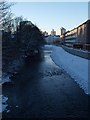
White Cart at Millbrae Road
The picture looks west along the White Cart from the bridge where Millbrae Road turns into Langside Drive. The winter afternoon's dying light reveals some of the topography of the immediate surroundings. The newly completed flood defences can be seen along the right-hand side.
Image: © Alec MacKinnon
Taken: 27 Nov 2010
0.13 miles
9
Newlands Road
Crossing Langside Drive, an area of big sandstone houses.
Image: © Richard Webb
Taken: 9 Apr 2013
0.13 miles
10
Langside Railway Station
Opened in 1894 by the Cathcart District Railway and today is part of the Cathcart Circle.
Image: © Paul Gillett
Taken: 28 Jul 2019
0.15 miles